
DRIFTLESS - Some who were suffering through a cold snap for the record books on Tuesday and Wednesday, Jan. 29 and 30, followed newscasters in referring to the event as the ‘Polar Vortex.’
Looking out at the projected wild, 79-degree temperature swing from 35-below-zero in the pre-dawn hours of Thursday, Jan. 31, to 44 degrees on Sunday, Feb. 3, I was tempted to refer to the extended weather event as the ‘Bi-Polar Vortex’ instead.
The weather the area experienced the week of January 27 through February 3 just kept bringing the hard knocks. The kickoff, which cancelled many schools and made travel extremely difficult came overnight on Sunday, Jan. 27 in the form of a snowfall, varying from nine inches in DeSoto to 5.8 inches in Prairie du Chien (seven inches fell in Gays Mills). This was quickly followed by a plunge in temperatures throughout the day on Tuesday that lasted through Thursday morning.
People were posting memes on Facebook that ‘Wisconsin is Closed,’ and that really wasn’t too far off the mark. In an almost unheard of move, local schools announced early Monday evening that they were calling off school, not just for the typical two-hour-delay or simply for the next day, but for the next TWO days. That doesn’t happen very often. Then, adding insult to injury, the perilous cold lingered into Thursday morning, causing schools to cancel yet again.
Another major indicator of the severity of the situation in Wisconsin, most area bars, eateries and even grocery stores and gas stations announced they would have early closing times to allow their staff to get home safely. There was even one news item that claimed that it was literally too cold to deliver beer, which some in Wisconsin would say is the hallmark of a bona fide crisis.
Many were exuberant when the temperatures climbed into the upper 30s and mid-40s over the weekend, but outside activities were conducted in a mysterious, foggy, misty world. With the rapid snowmelt and periodic drizzle, area roads became icy because the roadbeds were colder than the air. Many motorists had trouble with their late night drives on Saturday, Feb. 2, and most likely the danger just kept many folks home.
Farmers toiled long and hard throughout the cold days to keep water tanks thawed and full, dished out extra rations, and were literally saving lives. Parents struggled to entertain cooped up children who were home from school, and pet owners had to contend with surly pets who were cooped up in the house for safety.
First responders and sheriff’s deputies were out in the weather battling fires, responding to heath emergencies, and rescuing stranded motorists. Of course, healthcare workers and other workers had to start up their cars and go to work – though many citizens just stayed home.
There were reports of frozen pipes, and citizens were urged to clear the snow from around their electrical meters, furnace exhaust pipes and mailboxes. Postal service was officially suspended for two days.
Highway Department
“Yo-yo weather” is what the Crawford County Highway Department’s Todd Myers called the recent situation.
Myers, the department’s state patrol superintendent, and the rest of the county road crew worked hard to keep up with the constantly changing conditions over the past couple of weeks.
Temperatures that vary from 35 degrees below zero to 45 degrees sort of define “yo-yo weather.” So does precipitation that varies from eight inches of dry fluffy snow to freezing drizzle and even freezing fog.
This latest run probably started around January 22 or 23. First there was the ‘fake weather’ call-off-school non-snowstorm. That’s when the predicted four to eight inches actually turned out to be between a quarter of an inch of snow of Tuesday, Jan. 22.
A real snow of about four inches followed that on the morning of Wednesday, Jan. 23. By early afternoon, the highway department had the roads plowed and salted.
The snow restarted during the night of Sunday, Jan. 27 and accumulated to eight inches on Monday, Jan. 28. The highway department had little trouble clearing the light, dry snow.
Then, came the cold as the temperatures started to drop on Tuesday, Jan. 29 and the plow drivers kept working to hold back the drifting snow.
By Wednesday, Jan. 30 the temperature reached 30 below zero, and on Thursday, it reached 40 degrees below zero. With the extreme temperatures on Thursday, the Crawford County Highway Department kept most of the trucks in the garage, as the ones needed for plowing in a couple of places experienced gelling of their diesel fuel.
With Friday, Feb. 1, the temperatures started to increase and by Saturday the melt was on. However, refreezing on the night of Saturday, Feb. 2 into early Sunday morning brought trucks with salt back out onto the roads. The first trucks went out at 6 p.m. on Saturday and they stayed out as needed with the last one returning at 2 a.m. on Sunday.
Myers said the liquid brine being used on the county highways is helping the situation and adding sugar beet juice to the brine is helping it to adhere to the road surface. Myers indicated the brine mixture is much more effective than just salt, which can be more easily pushed off the roadway by traffic.
Myers said the county’s supplies for the brine, as well as sand and salt, are adequate at this point.
“The supplies are where they normally are at this point in the season,” Myers said.
Sheriff’s Department
“That’s life in Wisconsin,” Crawford County Sheriff Dale McCullick said of the recent weather.
So far, the sheriff is pretty happy with the way the winter weather has impacted the community. He noted that although there have been some weather-related accidents, none were extremely serious or life threatening.
“The winter weather has gone well for us,” McCullick said. “As the sheriff, and speaking for the whole department, I’d like to thank all the workers from the city, villages, townships and the county for the work they have done keeping the roads open. They’re doing a great job and for that we’re thankful.”
It was a moment
After the deep freeze finally lifted, citizens emerged from their houses on Saturday to shuck their layers and explode into a frenzy of winter sports such as snowmobiling, hunting and fishing. Westby had their biggest party of the year at the Snowflake Ski Jump, and citizens braved the icy roads on Saturday evening to attend the ‘Love the Land’ event put on by Crawford Stewardship Project in Gays Mills. From there, the party extended into Sunday with grilling out for Super Bowl festivities. It was a moment.
Now, launching into a new week, some citizens are wondering if the other shoe is going to drop as temperatures plunge , from an early-Monday-morning high of 39 to a low of 10 degrees.
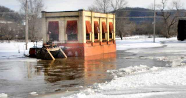
The National Weather Service began to issue warnings about ice jams on Sunday evening, and there were reports of high water and water over the road around the area.
A ‘Hydrologic Outlook’ was issued at 4:06 a.m. on Monday, Feb 4:
Recent mild temperatures combined with melting snow has led to the breakup of ice on many streams and rivers. With added water flowing into those waterways, ice jam formation is possible through tonight before temperatures cool rapidly below freezing again. Several reports of ice jams have already been received, and more are possible. If you live near waterways, be sure to monitor water levels and ice condition closely and be prepared to act if flooding develops.
I guess we’ll see if area streams and the Mighty Kickapoo River get jammed up and overflow their banks.
Record breaking cold
The record breaking cold was the coldest winter weather we’ve had since 1996. The change in temperature from Wednesday night to Saturday morning was the greatest three-day temperature swing – 79 degrees – since 1951.
What made the frigid air more dangerous - to deadly - was the addition of strong, gusty winds. Northwest winds were on the increase by early morning on the Tuesday, Jan. 29, blowing from 15 to 25 mph with gusts upwards of 40 mph throughout that day. Wind chills from -30 to -60 F resulted. Winds would subside a bit Wednesday, Jan. 30, eventually becoming light that night.
Record lows, including the wind chill factor, recorded in our area on Wednesday, Jan. 30, included:
Platteville Municipal Airport, -55F, 7:15 a.m.
Viroqua Municipal Airport, -55F, 5:55 a.m.
Fennimore, -54F, 8:40 a.m.
Prairie Du Chien Airport, -52F, 3:15 a.m.
La Crosse Regional Airport, -49F, 4:53 a.m.
Boscobel Airport, -46F, 8:53 a.m.
De Soto, -43F, 9:35 a.m.
Lynxville Dam, -40F, 9:30 a.m.
Polar vortex explained
Weather Underground meteorologist Bob Henson is the author of ‘Meteorology Today’ and ‘The Thinking Person's Guide to Climate Change.’ He provided this explanation of the term ‘polar vortex.’
Sometimes an obscure scientific phrase jumps into the popular lexicon and spreads like wildfire. The phrase ‘polar vortex’ has appeared in peer-reviewed journal articles since the 1950s, and it has been defined in the AMS Glossary for decades. It came into much wider use after science writer Andrew Freedman (now at Axios) began using it at Climate Central during the cold outbreak of January 2014.
This year, the phrase was inescapable—a convenient, easy-to-remember scapegoat. Brightly colored maps made it obvious where upper-level spin was focused over the Great Lakes, making the idea of the polar vortex even more tangible for laypeople.
There are actually two polar vortices, as pointed out in a 2017 Bulletin of the American Meteorological Society overview led by Darryn Waugh of John Hopkins University. There’s a large, asymmetric polar vortex that spins in the troposphere (the lowest few miles of the atmosphere) year round. A more compact polar vortex develops higher up, in the stratosphere, each fall and dissipates each spring.
According to Henson, this cold wave was extremely well predicted:
It can’t be stressed enough: forecasters saw this one coming. As far back as October, seasonal forecasts from The Weather Company called for the ‘back end’ of winter, especially February, to be colder than the first half of winter across most of the central and eastern U.S. When the sudden stratospheric warming occurred at year’s end, it began to raise the prospect of a fracture in the stratospheric polar vortex and the possibility of intense mid-latitude cold to come.
Finally, weather models correctly projected a week in advance that a lobe of the tropospheric vortex would invade the Great Lakes, bringing a memorable cold outbreak into the Midwest.
Henson went on to explain that one benefit of the extreme cold will be reduction in populations of the emerald ash borer.
This week’s intense cold will have additional victims, but welcome ones—the emerald ash borer, an invasive beetle that has killed an estimated 100 million ash trees in the United States since it was discovered in 2002 in Michigan. Cold weather kills emerald ash borer, with a mortality rate of about 5 percent when temperatures reach 0°F, 34 percent at -10°F, 79 percent at -20°F, and an impressive 98 percent at -30°F.
Perennial crop impact
Wisconsin specialists say last week's extreme cold could cause more winter-kill of fruits, alfalfa and other perennial crops in the state, according to an article by Hope Kirwan of Wisconsin Public Radio.
Amaya Atucha, fruit crop specialist at the University of Wisconsin-Madison, said grapes, apples and other fruits grown in the state aren't used to the frigid temperatures brought by last week’s polar vortex.
Ryan Prellwitz, president of the Wisconsin Winery Association, said many vineyard owners are worried about the buds that will produce this year's grapes. Apple growers are also expected to have to wait until spring to understand what impact, if any, the trees in their orchards have experienced.
He said producers can check buds during the winter, but they likely won't know the extent of the damage until spring.
When queried, Andy Meyer of Kickapoo Orchards didn’t think the severe cold would affect the coming year's crop too much if at all.
“We won't really know till spring,” Meyer said. “It may have killed off some weaker trees - all we can do is hope.”
Farmers with perennial forages like alfalfa can also expect to see more winter kill this spring.
Yoana Newman, forage specialist at UW-River Falls, said alfalfa plant cells freeze when temperatures drop below 5 degrees.
Newman said any fields without snow cover will likely see substantial winter kill, but she said some fields might be more resilient if farmers didn't harvest the last cutting in the fall.


