
The Lower Wisconsin State Riverway Board (LWSRB) heard a presentation from Dairyland Power Cooperative and Stantec about a proposed 69 kilivolt (kV) transmission line rebuild project. The power line comes south through Crawford County from the Bell Center substation, and crosses the Lower Wisconsin River near Boydtown and Woodman Lake.
“I would note that this is a totally separate issue from the controversial MariBell line, which is a 765 kV line proposed,” Cupp explained to the board. “Hopefully we can have a presentation on that line at a future meeting. We've been doing some research and trying to get a better understanding of that proposal, so any questions regarding that will probably be best served at a future meeting.”
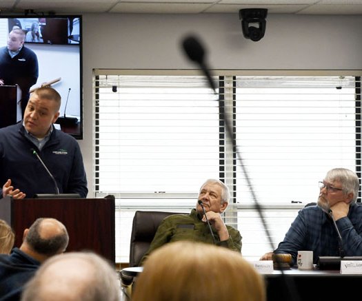
Representatives from DPC and Stantec present at the meeting included Staci Pieper, Dairyland Power Cooperative Project Manager; Mike Rask, Dairyland Power Cooperative Power Delivery Services Manager; Sarah LeMoine, Stantec Environmental Project Manager; and, Chris Schmidt, Stantec Environmental Permitting Lead.
LeMoine explained to the board that their purpose at the meeting was to introduce the board to their proposal in preparation for submitting an actual application for the project. That application would be considered at a future meeting of the board.
In images presented, the riverway board learned there are currently five wooden poles that take the power line over the Wisconsin River – three near Boydtown in Crawford County, one on a peninsula between the river and Woodman Lake, and one on the south side of Woodman Lake. She explained that the pole on the peninsula would be eliminated, and the other poles would be replaced with metal poles.
The last existing wooden pole to the north of the river is currently 126 feet, and would be replaced with a 140-foot metal pole. The current 56.5-foot wooden pole south of Woodman Lake would also be replaced with a 140-foot metal pole. The pole on the peninsula being removed, closer to the river, is a 105-foot pole.
“As part of this project, we did step through some different options. So of course, what if we did nothing and leave the line and structures in place, as is,” Le Moine explained. “The need driver for the project is that the infrastructure is aging. It's going to require reconductoring in order to be able to reliably continue to supply power. So, these aging poles just aren't going to be trustworthy and sufficient to sustain the reconducting that's required, and therefore will (need) replacement.”
Reconductoring is the process of upgrading existing overhead power lines by replacing old conductors (wires) with advanced, higher-capacity ones. This allows more electricity to flow without building new towers or acquiring new land. The technology uses stronger, lighter materials (like carbon fiber cores) to increase transmission capacity significantly, and lower costs compared to building entirely new lines.
“The second option was to consider an underground installation. We discovered that it was five to 10 times more costly to do an underground installation, especially due to the wide river channel crossing,” LeMoine explained. “When it comes to maintenance, those costs are typically higher as it's more difficult to access, and those repairs take longer and are more complex with an underground fix. This is especially true with the river and lake crossing, and a wider right of way would be required in order to maintain safety standards for that underground installation.”
LeMoine said this investigation led them to their third option, which is the project being proposed. She said the project scope included replacement of the two northernmost of the poles in Crawford County with steel poles, and the final pole in Crawford County and the pole south of Woodman Lake in Grant County would be replaced with taller steel poles. The existing wood structure on the peninsula between the river and the lake would be eliminated. This elimination would result in a slight easement shift, vegetation management to the east, and alleviate maintenance issues associated with access to the pole on the peninsula.
Images presented
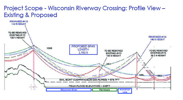
LeMoine showed the board an image of what the line would look like in profile, crossing the river, with the pole on the peninsula removed.
“You can see the significant sag in the line that had to be included as part of the design, and a lot of the driver for that is safety clearances, LeMoine explained. “The Wisconsin River does have a sailboat safety clearance. All navigable waters do. It's not unique to this particular river, and whether or not sailboats are actually utilizing the waterway. Also shown is the FEMA flood plain elevation, which is 648 feet, and the sailboat clearance elevation is 679.7 feet. So that's a lot of what's driving the need for the safety clearances.”
LeMoine said that the “belly” of the sag line would fall almost at the edge of where the peninsula meets the Wisconsin River.
“In the new design, the two poles closest to the water would be brown-colored, weathered steel,” LeMoine clarified. “This brown color would be more aesthetically pleasing, and blend in better than a shiny metal pole would. She said the poles would be secured on concrete foundations.”
LeMoine said that with the slight change in easement, any changes in vegetation management for the new 1.5 acres would occur on DNR land. She said that conversations with DNR are in progress, and that any tall vegetation on that land would need to be removed. She said that seeding would occur to ensure the area remained green, and low-growing vegetation could also be re-planted. She said that the area near the pole to be removed would be allowed to return to a natural state.
“From our initial discussions with DNR, it does sound like they're going to have some requirements to follow regarding the vegetation management,” LeMoine said. “Ultimately, a lot of that is going to be driven by DNR.”
Next steps
LeMoine said the project would be scheduled for 2027 through October of 2028. She said work adjacent to the Wisconsin River is only anticipated to take about two months. She said that standard construction methods and equipment are anticipated, with things like cranes to install the poles and the conductor at the two structures adjacent to the river. She said that matting would be utilized to help minimize runoff and compaction in an area that is typically very wet.
“The biggest meat and bones part of our presentation is making sure that we have the accurate depiction of the Riverway boundary and the board’s jurisdiction based on where our project falls,” LeMoine said. “We want to understand your area of authority as well, and whether or not a utility facility permit would be required for the construction of the project. Similarly, with all the aspects such as vegetation management, the new easement and the structure height changes. We think all of that combined would be within your jurisdiction, and would require a permit. We would love to hear more feedback about what may be involved in that process, and what some of the next steps may be, so we can be well situated to put a full and complete application together for your review.”
Board discussion
Cupp said he’d gone out on-site with Dan Hillberry and Rich Ten Pas from the Operations Committee to look at the existing structures. He said Hillberry’s long-standing association with Richland Electric Cooperative was very helpful in their discussions.
“One question we have is will the poles going beyond the project area, travelling up the bluffs in Crawford and Grant counties also be replaced?” Cupp asked.
LeMoine answered that those poles would remain the same height.
Cupp asked WDNR Riverway Park Manager Harry Stone if he saw any issues with the easement for the project, or if it was too early to tell. Stone said his work with WDNR Real Estate Division remains preliminary, but that discussion with Dairyland are in progress.
Cupp asked LeMoine how the pole on the peninsula would be removed.
“Typically, poles within wetlands are cut off at ground surface and left in place rather than pulling it all out and creating further disturbances,” LeMoine responded. “But sometimes easements have drivers with other requirements, so there is a bit to be determined.”
Cupp reminded them that at the preliminary meeting with them, he asked if anyone from Dairyland’s legal counsel could request some type of variance to the tall-masted sailing vessel clearance requirement.
“That is basically baloney,” Cupp said. “Were you able to find out anything about a variance or something else that may help us with reduction of pole height?”
“I don't know that we've asked anybody about that,” DPC’s Project Manager Staci Pieper responded. “We certainly can ask, though I’m fairly certain they're going to tell us no, that we can't do anything with the code because it's a code requirement. We can certainly try to follow up and ask that question.”
“Can you get that information to me to so I can relay it to the board, in case they want to pursue that by taking some kind of formal action to request such a variance?” Cupp asked. “As I've mentioned to you, tall-masted sailing vessels have never been on the Lower Wisconsin River. The very nature of the river would limit those deep-keeled vessels, and how would they get under the bridges? If that would allow us even a 20-foot reduction in pole height for the Woodman Lake structure, that would be a gain.”
Cupp said he also appreciated hearing that burying the line was considered. He pointed out that DPC had not specified a total project cost, but only stated that doing a buried line would cost 10 times more.
“I have an estimate on burying the line, although we have not put it out for bid,” Pieper said. “If we went that route, we'd work with a contractor because the equipment would be equipment we don't own.”
Larger project
Pieper clarified that the Wisconsin River crossing is part of a bigger project.
“This project starts in Bell Center and goes to Lancaster, so it's a fairly big project,” Pieper told the Board. “This is just a small piece in the middle, and to be clear on your question earlier, all of the poles on the project are being replaced. Some of them will go back as wood, and the majority of them will go back as either light duty steel or ductile iron. None of none of the existing poles will remain.”
Grant County representative to the board, Richard Ten Pas, asked if Dairylandwere to bury the line when crossing the river, what kind of distance would that involve?
Pieper responded they would bury the shortest distance possible because it is so expensive.
“Burying the line is really not something that we want to do, for a multitude of reasons,” Pieper said. “We have no buried line in our system, so I don't know how it works or how far away you would have to get to be able to pop that line back up and get it up a pole. I don't know much about it, because we don't do it.”
Cupp said, from maps provided, it looked like the span between the southern-most pole in Crawford County and the Woodman Lake pole in Grant County would be about 2,200 feet.
“I'd like to see some data. You say you don't have any buried lines,” Ten Pas commented. “What is the longevity of buried line versus suspended? And, I'd have to believe a buried line is much less apt to require maintenance than a suspended line. I think at some point in time you're going to have to bite the bullet and start burying lines. I don't think the future is in suspended electrical lines necessarily. So, is now the time to look at that? Or is that out in the future?”
Mike Rask, DPC Service Manager, said he could reach out to some of their contractors to see if an estimate would be available for the cost of burying the line at the crossing versus suspending it.
Aesthetic questions
Cupp asked if it would be possible for DPC to provide the board with visual imaging to demonstrate how the increase in the height of the Woodman Lake structure from 56.5 feet to 140 feet will affect the view shed when viewed from the river during leaf on conditions?
Rask said he thought that was something their engineer might be able to provide.
“Based on my experience with 36 years of administering the Riverway Law, and looking at various utility facility crossings, I think there's going to be a significant aesthetic impact with that new pole height,” Cupp said. “To have some type of conceptual drawing would be useful for the board in their decision-making process to assess the degree of that new visual intrusion balanced with the removal of the structure on the peninsula.”
Cupp also reminded DPC that he’d asked if some species like Wild Plum, that could grow to 12-18 feet, could be used along the water’s edge to cover up the “power line notch look.”
Rask responded that they had looked at this proposal, but that with the sag in the line being so close to the island, it would not be feasible. He said DPC’s vegetation staff supports planting of low-growing natural cover, but does not think planting even species like willow or dogwood would be advisable.
Richland County Board member Dan Hillberry asked if the pole in Crawford County were made a little taller, then could the pole near Woodman Lake be shorter?
Pieper said that all alternatives had been evaluated, with DPC’s preference for shorter versus taller poles for ease of maintenance. She said that the new conductor they’re using has less sag, meaning that the poles are 20-feet shorter than they would have needed to be if they continued with the current conductor.
Cupp asked DPC if they would be able to provide the board with the requested information by the Board’s March meeting? DPC responded that should be possible.