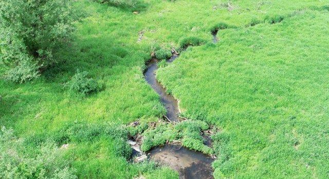
Crawford Stewardship Project’s (CSP) annual Karst Tour drew a crowd of about 50 to the Gays Mills Community Commerce Center on Saturday. The event featured a talk by Wisconsin Geological and Natural History Survey’s Dr. Eric Carson, and a visit to the Hogback Prairie State Natural Area near Steuben.
Dr. Carson is a Quaternary Geologist, and his primary research converges on the processes and sedimentary archives of streams near former glacial margins.
His interests range from millennial-scale variations in streamflow and flooding due to changes in past climates to historic records of landscape change and sediment mobility related to human-driven changes in vegetation cover and land use. Within this framework, the Driftless Area of southwestern Wisconsin is a prime example of this geomorphic setting, and a major geographic focus for his research.
Dr. Carson was introduced to the crowd by CSP’s new executive director Amy Fenn. Fenn discussed CSP’s updated mission of “uniting neighbors in care of human and natural communities.”
“What we really liked about this was the uniting neighbors,” Fenn explained. “I think our work’s always been about human and natural communities, but we're really excited about bringing in a new emphasis in bringing people together, especially in these divided political times, and our local landscape is something that we all care deeply about and have shared values about, and I think it's really great to emphasize that.”
Dr. Carson opened his talk with a joke about his casual attire, saying “I guess if you dress for the job you want to have, then I want to be a graduate student my whole life.” Carson kicked off his presentation with a picture of the mountains in West Virginia near where he grew up, saying the Kickapoo River Valley reminds him of his home.
“Today, I'll be talking about the geology and geologic research that I do along the Kickapoo River, and more broadly across the Driftless Area,” Carson said. “I do this from the framework of producing geologic maps, maps of the surficial sediment of the earth here in the Driftless.”
Carson said he was hired by the Geological Survey specifically because of his background with rivers and glaciers. He said that 17 some years ago, when they hired him, they turned him loose in the in the area, and the geologic mapping that he does has been one of the key components to his time here.
Carson said that updated geologic maps have been completed and published for La Crosse and Monroe counties, and updated maps for Grant, Iowa, Lafayette, Crawford, Vernon and Richland counties are currently undergoing a peer review. He said a tentative timeline for release of those maps is later this summer if all goes well. Maps for Trempealeau and Jackson counties are nearing completion, and in the future, if funding is received, maps for the rest of the Driftless Area in Pierce, Pepin, Buffalo, Rock, Walworth and Green counties will be developed.
“When we do our geologic mapping on a county-by-county scale, we do it at one to 100,000 scale. So everything is shrunk down to 100,000 times as small as it normally is,” Carson explained. “Historically, we did that because it made for a nice sized sort of poster when we printed them off. These days, we don't do printing anymore due to budget cuts, but we still do the work at that scale because it's good for understanding the geology and understanding geologic processes and geologic history.”
Carson was very proud of a surficial geological map of the State of Wisconsin that had recently been completed.
“We got we got funding from the U.S. Geological Survey, and had seven of us who had spent our entire careers looking at and studying the surficial geology of the state,” Carson said. “So all seven of us came together and made this map. The other example that's back on the back on the wall is another derivative map. So that's a map at a quarter million scale that shows the Driftless Area south of the Black River.”
Carson said that mapping is one angle of what WGNHS does. He said they do this because the mapping has value for the people in the counties. He explained that the maps help county boards, and various highway and zoning projects to understand how to use the land most responsibly. He cited examples such as determining where to site roads that are being built, where to permit and not permit CAFOs, and where to site landfills. But, he said, the maps are also a jumping off point for doing research.
Driftless Area
Carson told the group that the reason that the Driftless Area is so interesting to him is because it was never covered by any of the comings and goings of glaciers over the past two-and-a-half billion years. He explained that there have been numerous glaciations, ice sheets growing across North America, coming down out of Canada during that time period. He said that geologists don't even know how many, but for a variety of reasons, none of them covered over the Driftless.
“And so what we see is this landscape that's much, much older. We see landscape that's been evolving for millions of years. And it's this sort of window into an old landscape that I sort of pair my geologic mapping with geologic research to understanding the geologic history of the area,” Carson explained. “Because it is this old surface, and because, unlike the rest of Wisconsin that's buried under 10s or hundreds of feet of young glacial sediment, here we have a lot of the bedrock very near the surface.”
Carson showed the group a “stratigraphic” image, depicting all the layers of rock present in the state of Wisconsin, from oldest to youngest. He said that you would never actually see all these different rock layers in one place as is depicted in the image he showed. He said the oldest rock layers would only be seen up north, and the very youngest only in an area near Milwaukee.
“Right here in the Kickapoo Valley, the oldest rocks are a rock called the Wonewoc Sandstone. The place you'd see this is, if you go up toward Ontario and the Kickapoo Valley Reserve, and go out on the on the river, the sort of vertical walls of rock right at the river level,” Carson said. “The youngest rocks are a formation of rock called the St. Peter formation. It's a sandstone also, and if you wanted to see this, you'd actually have to go up to the top of the landscape. So, up on top of the ridge to the east of here, you'll sometimes see ledges or outcrops of rocks, and that's the St. Peter.”
Carson said the rock layers in the Driftless Area represents going from about 520 million years ago to just under 470 million years. He said that’s a window about 50 million years of sediment being deposited, but it's the best part of half a billion years back in the earth's history.
Carson zoomed in on a draft of the new geologic bedrock map for Crawford County. He said that narrow, dark squiggles on the ridgetops show where there is St. Peter sandstone. He said the map depicts the most abundant of the various layers either as a brick pattern (dolomite/limestone), or a pattern of small dots (sandstone), or as a pattern of dashes (shale). These rocks are all from what geologists describe as the ‘Cambrian’ and ‘Ordovician’ time periods.
“One of the things about the dolomite/limestone and sandstone layers of rocks is that they transmit quite a bit of water, and how they transmit the water varies on what type of rock it is,” Carson said. “The one we're really interested in is the limestones/dolomites, and the reason for that is that that kind of rock is probably about the only sedimentary rock we have that is easily dissolved.”
Carson said that “easily dissolved” in a geologic sense means that if you apply a weak acid to it, like rainwater, which is a very weak acid, it will dissolve over geologic time. Through the course of time, it will tend to form caves and cavern systems within it.
“So, when we see caves, they always occur in these limestones and dolomites. And when you have cave systems that get close to the Earth's surface, you start to have interactions between those caverns and the surface above,” Carson explained. “And that is fundamentally sinkholes. You either have the rock dissolving to form a conduit down into the cave, or if the cave gets too close to the Earth's surface, the roof of it will collapse and the sediment on top will collapse down. And so we get sinkholes that form in that way.”
Carson pointed out a prevalent layer of dolomite on the map that makes up the top of the landscape. He said that layer is the Prairie du Chien dolomite.
“So all the high surfaces in the county are this limestone that dissolves to form caverns, that dissolves to form sinkholes,” Carson said. “And if you were to go up into Vernon County, the amount of area that's covered by that rock is actually quite a bit bigger. Think about if you drive up to Viroqua, there's big, flat, open areas up there. And those are areas where we tend to have the karst forming. The other thing that is important is that water flows through limestones and dolomites. It does it by dissolving it, and opening canyons and caverns that the water can flow through.”
Carson said that water tends to flow very easily through another very common rock layer in the Driftless - the sandstones. He said that water moves through sandstone in a different way because it can't dissolve the sandstone, so it just flows in the microscopic pore space between the sand grains.
“So we have two different rock layers here that are very, very good at transmitting water,” Carson said. “Shale, a third and less abundant rock layer, is very, very poor at transmitting water, and that's because it's particles of mud that are flat and they're smashed together to form a rock. There's just no space for water to flow through. And so if we have groundwater flowing through this rock, water will be stopped in its downward motion, and moves along the top of that shale until it finds a place where it hits the Earth’s surface, and then you get a spring.”
Look back in time
Carson said that five million years ago, the Great Lakes did not yet exist because they were carved out by glaciers in the last two-and-a-half million years. He said that five million years ago, you would have seen the Missouri and the Mississippi rivers. The Mississippi flowed more through the middle of the state of Illinois, and was stopped to the north by the land formation known as ‘Military Ridge.’ He said the ridge is what is known as a ‘continental drainage divide,’ dividing water from water that flows one way and into one part of the ocean, from water that flows in opposite direction into an opposite body of water. So the Mississippi, according to Carson, only drained into the Gulf of Mexico from about just south of Dubuque.
“Five million years ago, on what is the Lower Wisconsin River today, which flows to the west, we had a river that flowed to the east,” Carson said. “So, the valley of the lower Wisconsin River was carved by a river that flowed to the east, and was part of a large river system that my colleagues and I have come to call the Wyalusing River.”
Carson said that other geologists in West Virginia and Pennsylvania had documented similar flow patterns for a river that existed five million years ago, which geologists call the ‘Pittsburgh River.’ That river and the Wyalusing River joined up to form a giant river system that flowed up into the Gulf of St. Lawrence, and then into the North Atlantic Ocean.
“Why don't we have this river system anymore? Well, what happened was the glaciers that covered the Earth numerous times. So if we jump forward to 2 million years ago, we would have had an ice sheet over Hudson Bay that was growing, getting larger, and flowing down to the south until it covered over a big chunk of that river system and dammed up the rivers beyond its border because they were all trying to flow up to the northeast.”
Carson said that as a result, all of the rivers formed enormous lakes on the margins of the glaciers. The one in the Driftless Area in what is now the valley of the Lower Wisconsin River is called ‘Lake Muscoda’ by geologists.
“You can think of the lakes as big bathtubs with the drain blocked and the water running,” Carson explained. “The downstream end of the valley is blocked by ice, and so it's going to keep filling up until it finds the lowest place to spill over somewhere.”
Carson said that glacial Lake Muscoda spilled over at Wyalusing, and cut a deep new path in the breach, and oriented the water to flow to the south, join the Mississippi River, and flow toward the Gulf of Mexico.
“And so that's how we got the system that we see today, that is actually only a couple of million years old, which is very, very young,” Carson explained. “And in the geologic world, the work done to understand that on the Wyalusing River was done on the Lower Wisconsin River by my colleagues and I.”
Modern history
Carson said that in the modern history of the flow of rivers in the Driftless, in the last million years, you had the Mississippi River that is a young river, and the Wisconsin River that's now flowing to the west. And you saw the windy, twisty, big, long Kickapoo River.
“The Kickapoo River is sort of the ‘King River’ in the Driftless Area,” Carson said. “It's the biggest of the rivers, and it's actually got some processes about it, geologically that make it quite unique compared to the other rivers surrounding it.”
Carson said that areas like the abandoned meanders of the Kickapoo River surrounding the high rock outcrop that makes up the Hogback State Natural Area are one of the unique things about the Kickapoo River Valley. He said the meanders are places where the river used to flow until it cut a shorter path.
“Part of the reason the Kickapoo River has abandoned former meanders and cut a new path is the history of the Lower Wisconsin River reversing its direction,” Carson explained. “When the Lower Wisconsin reversed its direction, there was a lot of down cutting into the bedrock by the river. So, the Wisconsin and Mississippi rivers beds are much deeper than what you see today. On the Mississippi and the Wisconsin, there's a lot of places that there's 150 or 200 feet of sand and gravel from the ground surface to get down to the bedrock floor of the valley. And the same thing happened here on the Kickapoo here, right near the town of Steuben.”
Carson said that in the area of the Kickapoo River Valley near Steuben, cores taken by his team have shown that it is about 97 feet from the surface to the bedrock floor of the valley.
“So as spectacular as you think the topography is and the depth of this valley is, just think about probably 30,000 years ago, it was another 100 feet to get down to the bottom of the valley,” Carson said. “So it was even that much more spectacular.”
Carson explained that during the period where the east-flowing Wyalusing River was dammed by the glacier, water had backed up into the valleys of tributary rivers like the Kickapoo and Pine rivers, forming small lakes. He said that cores revealing lake sediments taken in areas like the Hogback State Natural Area document the existence of these lakes.
He said that sand terraces, like the one that the new part of Gays Mills sits on, were formed during glacial times when the climate was much colder, and permafrost killed all the vegetation that held soil in place and protected the bedrock. Precipitation in those times eroded the top layers of sandstone, and sent massive quantities of sand down the river. The sand filled up the river bed, and was blown by the prevailing wind from the west onto the east side of the valley.