
Northeast Iowa, like Southwest Wisconsin, is no stranger to the impacts of heavy rain, and the stormwater runoff that contributes to flooding. In prior years, Rob Marlatt of the Turkey River Watershed Authority paid a visit to Coon Valley to learn more about the Coon Creek Community Watershed Council’s (CCCWC) efforts.
On June 5, a group of about a dozen CCCWC members, staff from Vernon County Land Conservation Department, and Ellen Voss of the River Alliance of Wisconsin, returned the visit. The group traveled to the offices of Northeast Iowa Resource, Conservation & Development (RC&D).
The day involved some presentations in the morning from Ross Evelsier, Natural Resources Project Director with the RC&D; Kate Giannini, Program Manager for the Iowa Flood Center (IFC); and Lee Bjerke, P.E., research engineer with the Iowa County Engineers Association. The afternoon was spent visiting NE Iowa regenerative farmer Loran Steinlage of FloLo Farms, and touring innovative flood control structures in the Turkey River Watershed.
Ross Elsevier
Ross Elsevier of NE Iowa RC&D explained to the group that the 2008 flooding event had really jump started flood mitigation efforts in the state.
“That was a pivotal event in Iowa flood history, and catalyzed a lot of action. In 2010 the legislature passed legislation to allow for the formation of watershed management authorities,” Elsevier said. “The other thing that they did was to allow formation of the Iowa Flood Center. This was allowed because there was really no one in Iowa working on flood mitigation. You have FEMA, Homeland Security, and emergency management that comes in and cleans up afterward or develops hazard mitigation plans for counties, but there's nobody doing active mitigation for flooding. So this was the first time that that was really a thing.”
Elsevier said that the Turkey River Watershed Authority was one of the first three formed in Iowa as a result of the legislation. He joked that including the word ‘authority’ in the name of the group was guaranteed to get people showing up at meetings.
“It became like an urban versus rural thing. The people from the city said this is a farmer problem. Farmers are causing all this. And the farmers said everything from the city runs off,” Elsevier explained. Our approach is that flooding is an ‘everybody problem.’ We all live here. We all share a watershed.”
Elsevier said that the Iowa Flood Center has been involved with Watershed Management Authorities (WMA) since the beginning. He said that everything they’ve been able to accomplish has been based on that partnership, because everything that the Flood Center has done has allowed the WMAs to visualize, and see what is an effective way to tackle it.
“Watershed work in Iowa has happened for a long time, and it's primarily been done through soil and water districts, so at that 10,000-to-12,000-acre scale. At that small scale, one watershed coordinator can work with all those farmers,” Elsevier explained. “But the problem is that doesn't address the full picture. So in a major watershed like the Turkey River, at little over a million acres, you start to kind of think like, what, what does it really take to move the needle at a million acre watershed scale? That's what the Flood Center has helped us do.”
For instance, Elsevier said that the first rain gauge network deployed by IFC was in the Turkey River Watershed, and was a partnership between NASA and Bob Astro.
“That network has really allowed us to be informed, and so that's changed how we looked at addressing these issues, because now we know what it really takes,” Elsevier explained. “And then you start to realize that to move the dial in a large watershed like the Turkey River, it'll take almost 400 to 500 detention structures to reduce flooding by a small percentage.”
Elsevier pointed out that it's easiest to stop the rain drop at the top of the hill where it lands, and that's where you can start those cheapest practices. On the other hand, he said that once the water starts to move downhill, it becomes more expensive, more engineered, and less efficient.
Elsevier gave a few examples of ways his team has worked with producers. Those include planting cover crops, and relay cropping as pioneered by Loran Steinlage. Relay cropping uses cover crops, but instead of terminating the cover crop in the spring, you actually just plant into it, and then you harvest both crops.
“To test the benefits of these types of practices, we put a hydro station in a relay cropping field, and then also in conventional field that's been continuous corn,” Elsevier explained. “Then, we looked at the data that we collected in terms of how the practices impact vapor, transpiration, and soil water infiltration. We took that data and put it out to the watershed scale for the Cedar River Watershed. We modeled that to say, like, what if everybody farmed this way? It doesn't have to necessarily be relays. It can be other regenerative practices, but generally speaking, what if everybody farmed this way, versus assuming that everybody's farming conventional - what would have happened in the 2008 and 2016 floods?”
Elsevier said that what they found is the 2008 flood would have been reduced by over 5%, and the 2016 flood would have been reduced by over 7%. He said that this modeled land use would have saved around 500 structures from getting inundated in both of those events.
“That's tangible results, just by planting something else,” Elsevier said.
Elsevier explained that they had also received funding from Housing and Urban Development (HUD) for a flood mitigation project in some of the subwatersheds of the Turkey River.
“We did around 30 detention structures on private land, and we also did on-road structures. We focused on very small (less than 1,000 acre) drainages to the structure,” Elsevier explained. “Since that time, people have noticed there's a difference when it rains.”
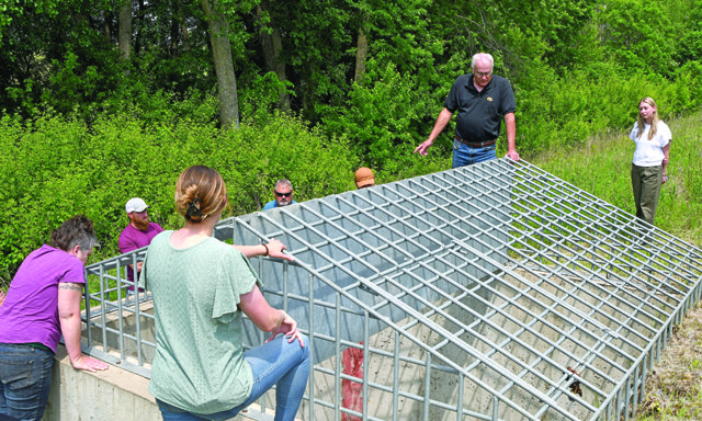
On-road structures
Lee Bjerke, P.E., works with the Iowa County Engineers Association as a secondary roads research engineer. He has been part of a team pioneering a new flood mitigation technique called ‘on-road structures.’ In Iowa, counties have a ‘County Engineer’ in the same way that counties in Wisconsin have a ‘Highway Commissioner.’
In his presentation, Bjerke referred to the structures as ‘a flood mitigation option for drainage structure replacement.’ According to Bjerke, an on-road structure (ORS) uses the roadbed as an earthen embankment that impounds normal storm flows using an undersized culvert that restricts water flow to a lesser volume downstream, releasing the water over time.
Basically, the structure is some form of a concrete intake tower, which accepts the backed up water but meters it out slowly through a box culvert that runs underneath the roadbed. The structures are designed to impound water for only a short amount of time – 24 hours or less, all the while metering it out through an ‘undersized’ structure. What this does is slow the water down, hold it back, and release it slowly. So, in an intense, heavy rainfall event, the structure is designed to withhold a certain amount of the total stormwater runoff to reduce flooding impacts downstream.
“At 18 hours, you're back to normal flow,” Bjerke explained. “And from a crop producer standpoint, if you're backing up on the crops, if you're inundating less than 24 hours, it's no problem, right? That's a great selling point.”
Rob Marlatt, chair of the Turkey River Water Management Authority Board, discussed how their group works with landowners to negotiate easements for the structures.
“Our county engineer was adamant that we pay these guys a flood inundation easement. So we paid them a one-time payment of 10% of the appraised value of the property,” Marlatt shared. “The idea behind that is when we do possibly inundate the crop, and it's the great grandson that has it, and they want to raise a little stink about it, we can say, yeah, we paid your grandpa for that.”
According to Bjerke, the benefits of such structures to Highway Engineers in Iowa include:
• slowing water through infrastructure, with downstream flows decreased, and thus damages decreased
• achieving slower downstream velocity, producing less scour and erosion, and less accumulation of debris
• improving the vertical geometrics of the roadway
• an improved roadway cross section
• enormous conservation benefits
• creating public-private partnerships.
Bjerke listed the drawbacks of the structures as:
• ponding, creation of a storage easement with a willing landowner
• intentionally creating backwater
• increased expense compared to replacement of the original culvert.
“With the structure that I have up on my screen, there's probably 25 acres that's under water, that's streaming through this thing, and that's your output. That's what we want,” Bjerke said. “Being an engineer, I came at this with a completely different mindset. I have to think about this because I'm going to kind of stop doing everything I've been taught up to this point. When you design a bridge or a box culvert or anything like that, in engineering you're taught checking backwater. What do you do? You're pushing water back. That's exactly what we're trying to do here is to push that water back. You have to change that mindset. If you've ever had an argument with an engineer, it's kind of like wrestling with a pig in the mud. At some point you understand the pig really enjoys it.”
Bkerke said the whole point is to reduce volume and velocity of the stormwater runoff, so when you do that everybody down below, including your own infrastructure benefits, because water doesn't pass through just one culvert or one bridge. It goes through multiple structures as it makes its way down, and every time you can make the flow less to the next one, you relieve the stress on that structure.
Kate Giannini, Program Manager with the Iowa Flood Center, explained that they received a grant from the Iowa Highway Research Board for a three-year project to map every possible location in the state of Iowa where an on-road structure could be placed. So now, you can go on to this information system, and it will show you anywhere in the State of Iowa where a potential site might be for an on-road structure.
Bjerke said that moving forward, now that the pilot project is completed, and the results proved out, will be:
• model the remaining 3,800 HUC-12 watersheds in Iowa
• get the engineers of Iowa using it
• applications for grants to expand the program.
“The cost to the State of Iowa for the 2008 flood was $10 billion,” Bjerke pointed out. “At a cost of $550,000 per on-road structure, 1,818 structures could be built.”
What would building 1,800 of these on-road structures mean for a difference?” Bjerke asked rhetorically. “I know 15% of Bear Creek now goes through one of these structures, whether it was the road structure or on private property, only 15% of the watershed, and driving through the watershed, I could see the difference. So if you don't think 15% is big, it's big. Does the 10 billion include personal property damage or death, or damage to infrastructure?”
FloLo Farms
Loran Steinlage, regenerative farmer and Aldo Leopold Conservation Award winner welcomed the group to FloLo Farm in the Otter Creek tributary of the Turkey River. While experimenting with cover crops and no-till practices, Steinlage saw an improvement in his soil’s health. He realized the cover crops would be more robust and beneficial if they were planted sooner. This led him to explore ways to inter-seed cover crops into standing fields of corn and soybeans.
Before becoming a pioneer in the practice of relay cropping, Loran drew inspiration by connecting with farmers across the nation through social channels and peer groups. Among the farmer mentors he credits with advancing his conservation ethic was the late Dave Brandt of Ohio.
“One of the first people that I saw doing relay cropping was Loran, and we've done a number of projects that I didn't even get to touch on this morning,” NE Iowa RC&D’s Ross Elsevier told the group assembled at the farm. “So actually, the first project I did with Loran is to do tile outlet sampling as a way to educate farmers on what's coming out of their tile outlets. That's when we started realizing we had something totally different going on out here. I think you were doing 40 tile lines at that time. And the biggest thing I always noticed was how the other tile lines were running, but the only time Loran’s would run is after a two-inch rain.”
Elsevier said that with the FSA office just down the road, they worked with them quite a bit.
“And then FSA found out that we were doing tile line monitoring on our own, and the tile lines here would have less nitrates than right down there in the woods where there's a spring coming out,” Elsevier said. “We would have more nitrates coming out of the spring all the time than we would out of the tile lines.”
Steinlage said that in the concept of regenerative agriculture, one of the things that he’d seen is incredible soil structure. But also, like the research team saw with the tile outlet sampling, you can see a difference when it rains on his farm versus other fields.
“A testament to that - you're all from areas with cold water systems, and know how fragile they can be. There are trout in the brook running through my field,” Steinlage said proudly. “You can't see the stream, but the grass waterway down there has a brook in it that goes all the way through. And there are trout in that stream. We had the DNR come down, and we actually shocked it. I got to do it with them.”
“They saw a lot of babies, so they're actually spawning up this far in a stream that is small and very susceptible to poor water quality,” Elsevier reported. “And so, that's, that's just another testament to what Loran's doing here.”