DRIFTLESS - About 50 people attended a presentation by Dr. Stanley Trimble at Sidie Hollow County Park in rural Viroqua on Sunday, Sept. 12. With rain on the way, the location above one of the 22 flood control dams in Vernon County seemed somewhat prophetic, though fortunately the rainfall that came was relatively minor.
One of the more noteworthy attendees at the event was Burton Lee, 91, of Coon Valley. Lee’s father Adolph was instrumental in the Coon Creek Watershed Project in the 1930s and 1940s. Burton Lee had been one of the first to step forward to work with Trimble’s research team, starting in 1974.

Coon Creek Watershed historian Marc Moilien, contacted after the meeting, had this to say about Lee:
“Burton Lee is a friend, neighbor and relative. He lives on a farm up in the end of a secluded valley. During these big rain events, he listens to the rumbling rocks and boulders in the two dry runs on either side of the buildings. He is very concerned and interested in soil and water conservation and wildlife. He is also interested in the Coon Creek Watershed group that has formed recently, and his daughter Jody is involved with the Tainter Creek Watershed Council. He has strong opinions on Soil Conservation and important questions. His wife and oldest son passed away in the last two years, which has been hard on him. Burton and his wife, along with Stan Trimble and his wife, have been good friends since the 1970s. Burton made the connection for me to go with Stan and Beth Baranski on a tour of the Coon Creek the last two years, and Beth got me started on studying Stan’s papers at UW-LaCrosse’s Murphy Library. Burton is a good source of history of Coon Valley and he likes to talk.
“Burton grew up on the Lee farm on the edge of Coon Valley (famous for all of the pictures of it). His father, Adolph Lee, was very involved in the soil conservation work in the 1930s. The tree nursery for the Civilian Conservation Corps was on his farm. Aldo Leopold would stop and visit Adolph because of the conservation work and their mutual interest in wildlife.”
Dr. Trimble, first at UW-Milwaukee, and later at the University of California-Los Angeles, conducted groundbreaking research about soil erosion in the Coon Creek Watershed. Trimble’s almost four decades of research built on the work of scientists who studied the watershed starting in the 1930s, where it is memorialized as the location of the nation’s first watershed demonstration project – the Coon Creek Watershed Project.
At his presentation, Trimble presented a saga of the Coon Creek Watershed that ranged from the stable pre-settlement hydrologic conditions to the devastation that began at the turn of the century, and reached its peak in the 1930s. Before the modern era of flooding that escalated in 2018, Trimble had observed that with the wide adoption of no-till management on hilltop farm land, the system had once again stabilized “as much as it can” under conditions of use of the land for agricultural production.
For Trimble, the flood of 2018 was a game changer. When he returned to the area to survey the damage in the aftermath of the rainfall and resulting widespread flooding, he was shocked to observe the impacts.
“The 2007 and 2008 floods exceeded anything I had ever seen before, but I was amazed at how well the landscape had handled those events,” Trimble said. “But my mind was blown by the 2018 rain event and flooding.”
Trimble had been particularly struck by the Coon Creek floodwaters overflowing the railroad embankment along the Mississippi River in Stoddard. To his knowledge, he said, this had never happened before.
“Given the flooding events we’re increasingly seeing, something is obviously going on,” Trimble said. “Up to this point, no-till management has been working, but at this point the ag technicians are going to have to come up with something more powerful than no-till.”
Trimble stated that he is skeptical that even the incredibly stable, pre-settlement landscape, could have handled the rain event that caused the 2018 flooding.
Measurements
Trimble’s measurements, taken following the 2007 storm, indicated that the upland no-till fields were not eroding and contributing additional sediment into the watershed. He said that sediment moving through the system was mainly legacy sediment, now moving from upper main valley areas like Coon Valley, and into lower main valley areas like Chaseburg.
But Monroe County Conservationist Bob Micheel, contacted after the meeting, has an updated view of the situation. His department uses a soil transect method yearly to measure the extent to which soil erosion is occurring in the county. In measurements from 2007 through 2018, Micheel has seen a steady and growing increase in soil erosion. In 2007, that amount was 2.2 tons-per-acre, and in 2018, the amount had doubled to 4.4 tons-per-acre.
Micheel attributed these changes to loss of dairy farms, and of dairy rotations on the landscape. Those rotations would include haylands and grass pastures.
In a conversation with the Independent, Micheel also agreed that starting in 2007, there had been a large withdrawal of acres enrolled in the Conservation Reserve Program (CRP), as prices for commodity crops grew. This demand for commodity crops created a corresponding increase in demand for cropland and rental rates increased. CRP payment rates could not compete with the increasing rental rates. The withdrawal from CRP resulted in many acres being taken out of perennial plantings and put back into production of annual row crops.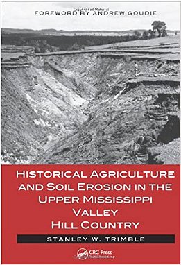

Trimble’s story
When Dr. Stanley Trimble stepped back from his 39-year career of documenting soil erosion in the Coon Creek Watershed, he had witnessed a miraculous transformation of a very troubled environment.
In his book, ‘Historical Agriculture and Soil Erosion in the Upper Mississippi Valley Hill Country,’ Trimble uses measurements taken by his predecessors, combined with photographs and other records to establish the full magnitude of the devastation that took place from about 1907 to 1940.
In his book, he tells a tale of settlers encountering the verdant valleys and valley terraces. Those valleys were rich in water resources, covered in perennial vegetation, and full of rich, black prairie (mollisol) soils that had evolved over centuries. So rich were those pre-settlement soils, they were considered to be ‘inexhaustible.’
Those settlers were from western and northern Europe, and were unfamiliar with rainfall and growing conditions in the wet and humid Midwest. Lack of crop rotations, especially perennial grassed rotations, grazing of forested hillsides, and methods of plowing, are what Trimble attributes the eventual destabilization of the landscape from about the 1860s to the early 1900s.
From there, through about 1940, it was a story of increasingly devastating soil erosion resulting from even the most minor of rainfall events. Valleys filled up with sediment, roads, bridges and railroads were constantly damaged, landowners retreated further and further up off the lowlands, where they had originally settled and farmed, agricultural land in valleys was turned unproductive, and whole communities disappeared.
Trimble’s account in his book reads:
“Thus, the combination of gradual soil deterioration, inadequate rotations, plowing up and down slope, and overgrazing led to increasing runoff and soil erosion, with rills and gullies eventually scarring the landscape. As soils became progressively thinner and less well structured, even more water and soil went down the rills and gullies with every rain. Valleys were covered with sediment, while small tributaries, flushed with the additional storm flow coming off cultivated and heavily grazed hillsides, began to erode their channels, sending even more sediment downstream.
“What drove the soil erosion, of course, was the hydrologic changes. Water that earlier had infiltrated, recharging soil and groundwater, now cascaded off slopes, causing erosion of the slopes and flooding in the streams, a runoff condition termed by hydrologists as ‘flashy.’ But, between storms, there was consequently less groundwater available to keep streams flowing (baseflow) so springs and small streams began to dry up. Although this was problematic for people, it also affected wildlife. For example, the original brook trout were largely extirpated by muddy floods followed by low flows.”
Transformation
In the book, Trimble extolls the transformation of the landscape that took place starting in the 1930s. He said that by the early 1900s, American agricultural experts had come to realize that techniques being employed by farmers were not adequate to cope with wind and water erosion. He said that, thus, states, followed by the federal government, started erosion control experiment stations with the goal of devising methods to mitigate soil erosion. One of these was the Upper Mississippi River Valley Soil Conservation Experiment Station established in 1931 near LaCrosse.
From that station’s efforts, it was found that:
• A one-year rotation of grass was inadequate to allow soil to regain its structure, infiltration capacity, and resistance to erosion. Rather it required a three-to-four year rotation of grass.
• Just planting on the contour was not enough. What was found necessary was to plant in contour strips of alternating land use such as corn, small grains and grass. In particular, it was found, grass intercepted the water and sediment from upslope, allowing water to infiltrate and sediment to be trapped.
• Improved crops such as alfalfa were introduced, which send down deep roots and encourage water infiltration. Other plants such as corn were improved to allow for denser plantings, which reduced erosion.
Demonstration areas were established, which allowed neighboring landowners to see the success of the methods, and to convince them to invest the time and money to change from the old ways.
In his book, Trimble writes:
“The utility of these demonstration areas was shown by the spread of contour-strip farming from the Coon Creek demonstration area to adjacent counties during the period 1939-1967. In 1939, contour stripping was limited to Coon Creek and its immediate environs, but by 1967, it was ubiquitous across the four-county area [Vernon, Crawford, Richland and Grant counties].
“It is important to note that the soil conservation revolution has never ceased in the Hill Country, or indeed in the United States. USDA Natural Resources Conservation Service (NRCS) and the Farm Services Agency (FSA) continued to work with farmers between 1982 and 1992, and this resulted in grassed waterways increasing by 28 percent, contour strip cropping by 11 percent, and terracing by 20 percent.
“Since the 1980s, there has been another conservation revolution: no-till farming. Instead of plowing the soil, seeds and fertilizer are injected into the soil, protected with a deadened grass cover.”
In his talk on September 12, Trimble said that the measures deployed on the landscape in the 1930s and 1940s had produced a ten-fold improvement in preventing soil erosion. He said that no-till farming had produced improvements that were “another order of magnitude.”
Watershed problems
At the end of his talk, Trimble described several problems facing watersheds in the Driftless Region.
First, he said that the increase in intensity of rainfall events due to climate change will pose additional challenges. As mentioned earlier in this article, Trimble believes that to contend with rainfall events like the one that caused the 2018 flood, agricultural techniques more powerful than no-till will be required.
Second, he said that legacy sediment from soil erosion prior to the 1930s is still moving through the system, and will continue to move. He said that moving the eroded soil is a process that will likely take centuries or more. He said this means that soil will continue to be moved from the upper reaches of watersheds into the lower main valleys. This has potential to continue to raise the level of floodplains in those areas, imperiling communities and public infrastructure.
Third, to the extent that no-till management is holding the soil in place on upland fields, the intensity of rainfall events means that greater amounts of clear water are coming off those fields. The relatively clearer water, which Trimble describes as ‘hungry water’ has more erosive power than muddy water. He said that these more powerful flood waters continue to move sediment, and are building up natural levees along streams, resulting in floodplains being cut off from the streams. This is resulting in more swamps, where areas that had been dry in the 1970s, when Trimble’s team had first worked there, being wet in the 1990s. As more sediment is deposited in the lower main valleys, the groundwater table rises, and basements previously dry will become flooded.