
KICKAPOO VALLEY - Reeling from the aftermath of historic flooding in the Kickapoo Valley, residents of affected villages are debating the future of their historic downtown areas. The floods were super-sized by the failure of three flood control dams in Monroe County, and two in Vernon County.
The dams reflect the heroic efforts of valley ancestors to construct flood control structures designed to protect communities downriver, and mitigate effects of inevitable flooding. Some of the structures put in place failed spectacularly in the face of an unprecedented rain event at the Vernon-Monroe county line in the early hours of Tuesday, August 28, 2018.
Those ancestors were also noteworthy for being ‘Cooperators’ with the county Soil Conservation Service land management programs. Indeed, the high level of cooperation was one of the requirements for the structures to be built.
All of the work plans written to convince the U.S. Congress to approve construction of the dams, and to appropriate the funds, made clear that the dams would only function in the context of conservation land management on ridge top lands.
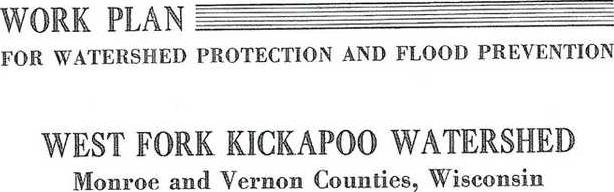
Two of the first ‘pilot’ dams to be constructed in the West Fork of the Kickapoo, Mlsna and Klinkner, were built in 1956. Language in the ‘Work Plan for Watershed Protection and Flood Prevention for the West Fork Kickapoo Watershed (WFWP),’ approved in May 1961 reads, “The first approach to watershed protection was a program of sound soil and water conservation measures. An 18,000-acre pilot watershed under P.L. 156, 83rd Congress, was established in the upper reaches of the West Fork in 1956 because more than 50 percent of the farmers were cooperating with their soil and water conservation district. It was believed then that this would be a good demonstration area for structural flood prevention. In August of 1959, a storm of 50-year frequency caused severe damage in the entire West Fork except in the (Knapp Creek) tributary controlled by the pilot project. This flood experience aroused the people of the valley and brought about an application for assistance under Public Law 566 (PL-566, ‘Watershed Protection and Flood Prevention Act of 1954’).
Residents of the Kickapoo Valley had experienced a massive flood in 1951. The floods and flash floods of 1959, like the more recent 2016 flood and flash flooding event, triggered activation of local populations around their mutual interests in conservation and flood prevention.
The 1959 storm stimulated the formation of the West Fork and Blackhawk-Kickapoo Watershed Associations. Now, after the 2016 event, we’ve seen the rebirth of those two organizations as the West Fork Watershed Council and the Tainter Creek Watershed Council. There has also been talk recently of a watershed group forming in the South Fork of the Bad Axe River.
The WFWP eventually called for construction of eight flood control structures in the West Fork, including the two pilot structures built in 1956. The requirement of a high level of participation of landowners in conservation land management continued to be a condition of the agreement.
“The (soil conservation) district is required to obtain conservation agreements for at least 50 percent of the land above each structure as a condition to providing financial assistance for construction.”
The plan called for 2,070 acres contour strips, 7.45 miles of diversions, four gully control structures, wildlife plantings, pasture improvement, woodlot improvements, stream bank protection and more.
A wetter climate
Our area has seen steadily ramping up levels of rain dumped in increasingly catastrophic rain events in recent years. These events hit with ‘Russian Roulette’ unpredictability. Conservation land management in flood-prone watersheds is more important than ever.
No-till grain farming was lauded as ‘the solution’ to soil erosion on ridge top farmland. It has helped control soil loss, but does not stop the runoff of water and nutrients into the watersheds. Locally, there are increasingly fewer animals in farm rotations, and a corresponding decrease in pasture.
With grain prices so high a few years back, many of the old contour strips and terraces were removed to make way for ever-increasing planting of corn and soybeans.
Solutions in the aftermath of floods always seem to involve state and federal agencies coming heroically to the rescue with an economic bailout. Conservation land use measures were left as ‘voluntary,’ and many chose to opt out.
At a recent ‘Farmers and Fishers’ event held on the grassfed beef farm of Vernon County Supervisor Rod Ofte, one Minnesota farmer invited to tell his watershed council story had another tale to tell.
“Our watershed group is more oriented to doing versus talking,” John Bruihler, a member of the Rush/Pine Farmer-Led Council in Minnesota’s the Root River Watershed said, “After trying with mixed success to get my neighbors to sign up for conservation practices such as installation of cover crops, I’ve come to the opinion that conservation land management might need to be written into law.”
Kickapoo Valley shifts
The four counties in the Kickapoo Valley, Monroe, Vernon, Richland and Crawford, show a clear history of shifting land use practices, based on U.S. Census data from 1930 to 2012.
Between 1959 and 1964, acres farmed on the contour in the Kickapoo Valley’s four counties increased by five percent, from 130,579 acres to 137,590 acres. Between 1964 and 1969, they decreased by 43 percent, down to 78,132 acres.
Between 1959 and 1964, acres farmed in strip crops in the Kickapoo Valley’s four counties increased by five percent, from 182,658 acres to 191,800 acres. Between 1964 and 1969, they decreased by 36 percent, down to 122,718 acres.
Acres enrolled in the Conservation Reserve Program (CRP) began to appear in census data in 1978. Acres enrolled in CRP in the Kickapoo Valley’s four counties in 2002 had increased from acres reported in 1978 by 434 percent, from 14,522 acres to 63,008 acres.
Between 2002 and 2012 there was a sharp decrease in acres enrolled, by 46 percent, down to 33,994 acres. This decrease in enrollments seems to correspond with the increases in commodity prices for corn and soybeans in the time period.
Acres planted in corn in the Kickapoo Valley’s four counties increased from 1935 to 2012 by 41 percent, from 130,766 acres up to 221,355 acres.
Acres planted in soybeans increased from 1935 to 2012 by 346 percent, from 21,952 acres up to 76,163 acres. The jump in soybean acres between 1997 and 2002 was particularly dramatic, increasing by 253 percent, from 22,666 acres up to 57,400 acres.
Meanwhile, acres in pasture in the Kickapoo Valley’s four counties decreased between 1930 and 2012 by 83 percent, from 843,874 acres down to 141,430 acres.
Numbers of cattle for all purposes in the four counties reached a historic high in the 1987 census data. In all cases, the numbers in 2012 were more or less back at 1935 census levels.
The number of cattle grew by 41 percent between 1935 and 1987, and then shrunk by 39 percent between 1987 and 2012.
Crawford County always had the lowest number of cattle of the four counties, and the 2012 number of head was 16 percent lower than the 1935 level, with Richland County at 11 percent lower than in 1935. In 2012, Monroe County had 11 percent more cattle than in 1935, and Vernon County had one percent more.
The decline in acres in pasture or hay in the watershed is likely linked to the decline in numbers of cattle.
Keep it covered
Retired USDA-NRCS soil scientist Ray Archuleta recently spoke to a group of almost 200 farmers and interested citizens at an event sponsored by the Tainter Creek Watershed Council, with funds provided by the DATCP Producer-Led Watershed Grant Program.
Archuleta said that all farming systems, whether organic, which relies on tillage to control weeds, or no-till monocultures, are falling short of optimal productivity. He emphasized that tillage should really be called ‘tillagecide,’ because it destroys the soil microbiology and reduces water infiltration.
Even no-till without cover crops will produce these unwanted results, because when you leave the soil uncovered after harvest, with no living roots in it, then you are not building and restoring the soil biology, according to Archuleta. When you don’t have the ‘glue’ in the soil to hold it together, then the soil doesn’t hold calcium or nutrients.
“Sixty percent of the water in our system comes from the oceans,” Archuleta explained. “A little known fact is that the other 40 percent comes from inland evaporative transpiration. We’ve disrupted the ‘little’ water cycle, and that’s why we’re getting the bigger rains. And flooding is basically a problem of lack of infiltration in the soil.”


