
DRIFTLESS - When you’re a pioneer, it’s often but not always, good to follow in the tracks of those that have gone before. Monroe County is one of just a handful of counties in Wisconsin to have formed a Climate Change Task Force (CCTF). That task force is now forging ahead with pioneering a water level monitoring and flood prediction system of devices in two of the four watersheds with headwaters in the county (Kickapoo, Little LaCrosse, Lemonweir, and Baraboo Rivers).
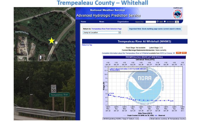
Monroe County shares their northern border and yet another drainage basin (Black River) with Trempealeau County. So, it was a no-brainer for the Monroe County folks to go up and take a look at the system Trempealeau County has been operating for the last eight years. That system for water level monitoring and flood prediction uses one of the types of devices Monroe County is considering, and is integrated with the National Weather Service in LaCrosse as well.
Trempealeau County
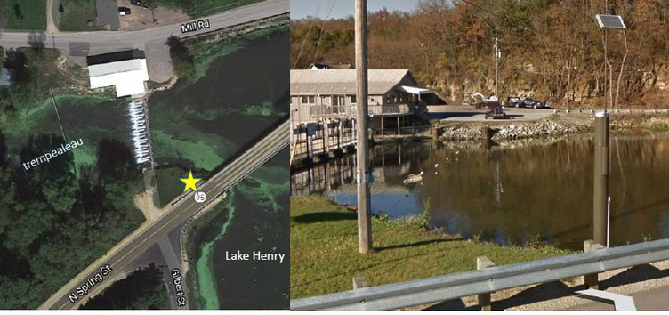
A Monroe County team reviewed two locations in the Trempealeau County system. Monroe County Land Use Planner Roxie Anderson confirmed the team had visited two locations in the Trempealeau County system during their visit. One of those locations was the Blair Mill Dam on the Trempealeau River.
Trempealeau County has used their system of High Sierra instruments for eight years. They chose radio antennae for data transmission, storing it on in-house servers. To communicate the data out, they partner with NWS. Data is transmitted when a change occurs, and if there is no change, data is transmitted every 12 hours.
For their monitoring stations, their High Sierra instruments are solar and battery powered, with a rain gauge sensor with a tipping bucket, water level sensors, and a configurable data transmitter.
The county’s system was installed by a third-party contractor. The devices consist of a 10-foot aluminum standpipe encasement with a security-locked access panel, and is secured in place by concrete. It has conduits for water level sensor cables. Although it has a weatherproof design, dessicants are also used to prevent moisture damage to electronic components. The stations are covered with wooden boxes in the winter to protect them from extreme weather.
“Having these stations in place allows them to have real-time information available about rainfall amounts and water levels without having to physically go out and make the observations,” Monroe County Conservationist Bob Micheel said. “In the process, they are gathering a valuable data set at locations that might otherwise be unmonitored, and their partnership with NWS allows for experienced professional interpretations of the data and the issuance of alerts and notifications to their emergency management personnel.”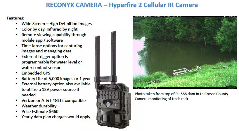

Another feature that is used in the county are remote cameras, which can help to monitor locations and features such as trash racks at flood control dams or particular spots on roadways.
The cameras provide wide screen, high definition images in color by day and infrared by night. The images can be viewed remotely with compatible software that can be used by mobile devices, and have embedded GPS. Their battery life is for 5,000 images or one year, and can also be connected to an external 12-volt power system. They are cellular network compatible, and the estimated cost per unit is $660.
Monroe County
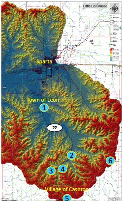
Micheel reported that six locations have been selected for monitoring stations in the Little LaCrosse River Watershed, and eight locations in the Kickapoo River Watershed. All locations have been vetted for cellular network reception.
In the Little LaCrosse River Watershed, the following locations and equipment are proposed:
• Town of Leon –Jancing Avenue Crossing: Water Level Sensor, Camera Sensor, Road-side Warning
• County F Crossing: Water Level Sensor, Camera Sensor
• Nebraska Avenue Crossing: Water Level Sensor (this will also serve as a monitoring site as part of the Fisher and Farmers Partnership grant)
• Market Road Crossing: Water Level Sensor (Village of Cashton Wastewater Treatment Plant has a rain gauge station. Data sharing will be coordinated)
• Village of Cashton: Rain Gauge Sensor
• St. Mary’s Ridge: Rain Gauge Sensor

In the Kickapoo River Watershed, the following locations and equipment are proposed:
• Village of Norwalk –Railroad Street Crossing: Water Level Sensor
• Village of Wilton - Highway 71: Water Level Sensor (establish rain gauge in Village of Wilton)
• County Z: Water level sensor, rain gauge sensor
• County T Crossing: Water Level Sensor
• Village of Ontario, USGS Gage Station –data sharing
• St. Mary’s Ridge: Rain Gauge Sensor
• County U –Helgren Farm: Weather Underground Registered Personal Weather Station
• Nevada Road – Firefly Ranch: Weather Underground Registered Personal Weather Station
“Our selection of sites took into account historic flooding knowledge, cellular reception, and existing resources,” Micheel said. “We’ve narrowed it down to the information we know we need to have and are just waiting on a few more cost estimates to move forward.”


Micheel said that through the Kickapoo Valley Association’s donation initiative, it is looking likely that there will be municipalities, businesses and individuals who will contribute toward the cost of purchase and installation of the systems.
Counties that are interested in installing similar systems, and would like to be considered for donations, have to set up a dedicated, earmarked account as Monroe County has done. More information about the Kickapoo Valley Association’s initiative and downloadable copies of donation brochures, can be found at: http://www.co.monroe.wi.us/committees/climate-change-task-force/.


