At meetings held last week in Cashton and Coon Valley, the USDA Natural Resources Conservation Service recommended decommissioning the flood control dams in the West Fork Kickapoo and Coon Creek. The exception was the Jersey Valley dam, which they recommend rebuilding downstream.


Information about the economic analysis is available at the project website at:
https://www.wfkandccwatersheds.com
From there, the remaining third of the $1.66 million granted for the study will be used to refine the study for the option selected by the counties. At that time, an Environmental Impact Study will also be undertaken, followed by another public comment period.
Cost-benefit ratio
After intensive inspection of the stability of the dams, the condition of concrete and steel used in construction, the fractured bedrock in the hillside abutments, and an intensive economic analysis, NRCS determined that it would cost more to relocate the dams than the value of the flood control to be realized. This was also true of the Jersey Valley Dam, but because of the value of the dam and park for recreational purposes, they say it makes economic sense to relocate it.


The critical result of NRCS’ year-long economic analysis was the cost-benefit ratio for each dam. In the economic analysis, in order to justify federal investment, the ratio must be a minimum of one-to-one. That means that for every dollar spent the project would need to produce at least one dollar’s worth of flood control.


According to Steve Becker, NRCS State Conservation Engineer, and other engineers involved in the study, the real problem is the underlying fractured karst geology of the Driftless Region. This geology means that in order to build safe dams, the costs will be much higher than when the original dams were built. Additional costs would come from concrete wing walls at the abutments with the hillside, foundation drainage, and an armored auxiliary spillway in the middle of the dam.
According to one of the geotechnical engineers working on the evaluation of the dams, design techniques and geological investigations have changed a lot since the dams were originally built.
“The karst geology of the Driftless Region presents special challenges for dam design and performance,” Geotechnical Engineer Ben Dougherty said. “We learned that when the Grand Teton Dam failed in 1976, and in retrospect there was neither the more advanced techniques we can bring to bear today, nor was the funding available, to do the kind of geological investigation that we now know is needed to build safe dams in the Driftless.”
The study concluded that repairing the dams in place would not be a cost effective option, and is estimated to cost 50 percent more than relocating the dams. There are significant concerns about the stability of the current dams. This involves seepage in the hillside abutment area as well as possible internal erosion near the spillways, which in some cases are experiencing separation at the seams. To fix the dams in their current location would involve tearing them completely apart. It would be cheaper, NRCS says, to relocate the dams downstream so the material would only need to be moved once.

Aggregate approach
Although the immediate cause of the study was the two breached dams in the West Fork and the three in Coon Creek, NRCS says the dams were built to work together as an aggregate to achieve flood control in the watersheds. For the breached dams, their proposed solution is to notch them to create an opening big enough to pass a 100-year flood – that is 7.5 inches in 24 hours. The area of the notch would also be shaped and re-vegetated. The sediment behind the dams would not be removed because it would make the cost of the project too high.

The initial focus for decommissioning will be on the breached dams, and other high hazard dams (dams with people and structures in the hydraulic shadow) like Ostrem and Pilot Kinkner in the West Fork. In Coon Creek, it would be the Melby, Baltz-Amundson, Korn Coulee and Dahlen dams.
The focus to start would be on those dams that have not breached, but whose failure has the possibility to endanger human life. Another option would be to remove the homes and businesses in the hydraulic shadow causing the dam to be classified as high hazard.
Decommissioning of other dams in the two watersheds would be recommended when the cost of operation and repair exceeds the economic value of the structure. The federal economic interest in the dams is considered complete after 50 years.
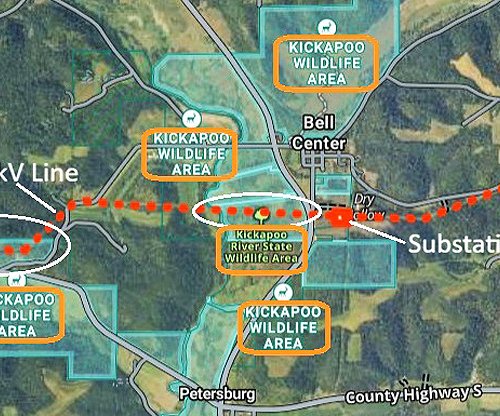
Ultimately, according to Steve Becker, NRCS State Conservation Engineer, the standard set for dams in Coon Creek and the West Fork will set the standard for determining the future of all of the PL-566 dams in Southwest Wisconsin. So, eventually this lens will also be brought to bear on dams in the Bad Axe watershed and the Blackhawk-Kickapoo Dam in Crawford County.


Other dams
In the West Fork Watershed, the other dams have been given a priority to decommission rating by NRCS. The remaining structure life without repairs for Ostrem (1964) is estimated at 5-10 years. The other dams are estimated at 10-15 years – Hidden Valley (1966), Seas Branch (1968, high hazard), Jacobsen (1964), Clockmaker (1971), Yttri-Primmer (1969) and Pilot Klinkner (1956 high hazard.
In the Coon Creek Watershed, Swenson (1962), Melby (1962 high hazard), Baltz (1961 high hazard), Mashak (1961 high hazard), Korn Coulee (1960 high hazard) and Dahlen (1962 high hazard) have an estimated remaining structure life of 5-10 years. Struxness (1962) has an estimated remaining life with out repairs of 10-15 years. Garlick (1962), Peterson (1963), Cornell (1962) and Berg (1963) have an estimated remaining structure life without repairs of 15-20 years.
Of the dams in the Bad Axe River Watershed, Raaum, Thompson, and Eagle’s Park are 58 years old; Sidie Hollow and Tally are 56 years old; Runge Hollow is 47 years old; and Duck Egg is 34 years old.
In Crawford County, the Blackhawk-Kickapoo Dam on Johnstown Road is 46 years old.

The dams in the Bad Axe River Watershed, and the Blackhawk-Kickapoo Dam in Crawford County were not included in the current NRCS study.
“Over the years, of the 23 dams located in Southwest Wisconsin, Runge Hollow, Dahlen, and Clockmaker failed, and now five more dams failed in 2018,” Becker pointed out.

Value of the dams
The economic analysis presented at the meetings is considered preliminary, and will be refined once the counties select their preferred alternative. Benefits from the dams are considered to be flood costs avoided by having the dams since the 1960s. According to the NRCS team, preliminary indicators of the benefits are:
• the original purpose of protecting land use is small because the dam shadow acreages are low
• avoided streamside infrastructure damages and lower emergency services benefits are higher
• recreation, particularly the blue-ribbon trout fishery and Jersey Valley, are dominant benefits
• structure and crossing avoided damages are still being calculated


The economic analysis of the value of flood protection provided by the West Fork dams is $2,839,037 for land uses (5.5 percent), infrastructure and services $1,690,419 (3.3 percent), and recreation $46,738,902 (91.2 percent). This comes to a total of $51,259,358, of which the recreational value of Jersey Valley alone is $43,812,581.
The original system cost of building the dams was $33,870,379, and their net present value is $17,388,979. This gives them a retrospective cost-benefit ratio of 1.57.
The economic analysis of the value of flood protection provided by the Coon Creek dams is $2,027,530 (17.6 percent) for land uses, $3,461,536 (30.1 percent) for infrastructure and services, and $6,016,726 (52.3 percent) for recreation. This makes the total value $11,505,792.
The original system costs of building the dams was $13,304,083, and their current net present value is negative at ($1,798,291). This gives them a retrospective cost-benefit ratio of 0.93.

With/without dams
For the West Fork Kickapoo, the dams control runoff from 35 percent of the watershed. With all dams in place, the 100-year floodplain is 2,149 acres. With none of the dams, the 100-year floodplain would increase by 270 acres to 2,419 acres. Without the two failed dams (Jersey Valley and Mlsna) but the rest of the seven dams in place, the 100-year floodplain would increase by 92 acres to 2,241 acres.
For Coon Creek, the dams control runoff from 19 percent of the watershed. With all dams in place, the 100-year floodplain is 2,705 acres. With none of the dams, the 100-year floodplain would increase by 228 acres to 2,933 acres. Without the three failed dams (Luckasson, Korn and Bilhovde) but the rest of the eleven dams in place, the 100-year floodplain would increase by 91 acres to 2,796 acres.

According to NRCS, most of the flood control benefit except in the local areas controlled by the dams, has come about from historic changes in upland land conservation practices put in place starting in the 1930s. According to a 1996 Rainfall-Runoff Characteristics Study for Coon Creek, agricultural practice changes from the 1930s to the 1980s reduced the two-year peak discharge by 72 percent and the 100-year peak discharge by 53 percent. These practices had been installed and were in their hey-day prior to construction of the dams.
“When Krug did his study of 1978, the dams were in place, and so his results reflect the presence of the dams,” Becker said. “His results show that the dams reduced peak flow from a 100-year storm by 17 percent, and conservation land treatment reduced it by 53 percent.”
The dams provided additional peak discharge reduction that was added to the baseline provided by conservation land management. The original 1958 Watershed Work Plan for Coon Creek estimated that land treatment would reduce the peak discharge from a 50-year flood by 11.7 percent and a five-year flood by 15.7 percent. In the original West Fork Kickapoo Work Plan it was estimated that land treatment would reduce total flood damages by just six percent.
When calculating the peak discharge of different practices – conservation land treatment or flood control dams – engineers use what is called the ‘curve number.’ Basically, the lower the number, the more flood control benefit. In the analysis currently in progress, NRCS estimates that the curve number could be lowered from 71 to 64 through land management practices. To match the protection provided by the dams, that number would have to be 38.5.

Tim Hundt from Congressman Kind’s office asked if the models the NRCS team used account for changing weather patterns or if they are using the 2012 Atlas 14 data?
“We were required to use the 2012 Atlas 14 data,” EA Engineering Sciences Robb Lutz said.
“As part of the study I had Dr.s Eric Booth and Dan Wright of UW-Madison commission a study on updated rainfall amounts for the region,” Steve Becker said. “We have the data, and will run it through the final preferred alternative selected by the counties – with the cost-benefit ratio so low for replacing the dams, it wasn’t worth doing on the front end.”


The UW study compared the mean rainfall depths from Atlas 14 to the mean rainfall depths derived from the UW analysis,” Becker said. “It shows that the 24-hour rainfall depths for the various storm probabilities have increased about 0.6 inch. Higher precipitation depths will increase the projected benefits of watershed dams, and the configuration of new dams. The question is how much? The planning team will examine the effect on the economics and the configuration of replacement dams in the next phase of the study.”


Land use
Monroe County Conservationist Bob Micheel presented findings from another part of the study conducted by researchers from UW-Madison about land use trends in the Driftless. He said there has been a steady uptick since about 2007 in the amount of soil erosion (2.2 tons/acre/year in 2007 and 4.4 tons in 2018), and aerial photo analysis revealed a 28 percent decrease in the area managed with contour strips from 2004-2018.

“Land use data from the agricultural census shows a shift in our area from dairy rotations that included hay,” Micheel observed. “What has replaced that are corn-soy rotations where there is less opportunity for the land to be managed in contour strips.”
Tim Hundt asked if use of more advanced regenerative conservation practices to improve soil health would change the analysis?

“Basically, to really make a difference with land use, you would have to go beyond farmer’s social and economic comfort,” Senior Natural Resources Engineer with EA Engineering Tim Haakenstad said.
Cost of alternatives
From the study results released by NRCS for Coon Creek Watershed, the retrospective analysis for those dams shows a 0.92 cost-benefit ratio. For this reason they are recommending that the dams be decommissioned. To decommission the three failed dams in that watershed would cost $2,861,300. Federal cost share on the project would be 65 percent, which means the counties would have to pay $1,001,455. To replace the three breached dams would cost $12,300,000, and federal money would not be available because of the cost-benefit ratio.
For the breached dams in the West Fork, Jersey Valley has a cost-benefit ratio of 2.9 and Mlsna has a cost-benefit ratio of 0.92. To replace the two dams would cost a combined $24,300,000 - $19,900,000 for Jersey Valley and $4,400,000 for Mlsna. Because of the cost-benefit ratio, no federal funds would be available to replace Mlsna.
Federal cost share to replace Jersey Valley would be 65 percent under the rehab portion of Public Law 566 (PL-566), but cost share would be discounted by 50 percent for any portion of the project that related to recreational development versus flood control.
To decommission the two breached West Fork dams would cost a total of $6,696,100. Of that $4,500,000 would be for Jersey Valley and $2,196,100 for Mlsna. At 65 percent cost share, the counties would pay $1,575,000.
If the Mlsna Dam were decommissioned, this would increase the flow depth at the Bloomingdale bridge in a 100-year event from 10 feet to 11.1 feet. The bridge overtops at 10.7 feet. For the bridge at Avalanche, with all the dams the flow depth is 7.5 feet, with the dams removed, the flow depth increases to 8.4 feet, and with all but the two breached dams remaining, the flow depth would be 8.1 feet.
If the three breached dams in Coon Creek were decommissioned, it would increase the flow depth at the Coon Valley bridge to 15.6 feet, versus 15.5 feet with the dams. At the Chaseburg bridge, flow depth without the dams would be 12.4 feet versus 12.1 feet with the dams.

Jersey Valley
The engineering team has developed a preliminary proposal that the Jersey Valley Dam could be rebuilt just downstream (perhaps 500 feet, though no specific location has been identified yet) in the watershed. The current impoundment or lake would be retained as a sediment collection pool and the new lake would be below the old dam and above the new one.
The old dam would not be completely removed, but would be reduced in height. It would still function as a walking trail and a fishing pier.