DRIFTLESS - Back in the heyday of PL-566 dam construction in the Driftless Region, a low-cost method of reducing stormwater runoff that can lead to flooding was the subject of research at the Coulee Region Experimental Forest in rural Bangor. The runoff reduction method is considered to be as or more effective than other conservation land treatments, and avoids taking cropland out of production.
Led by the Wisconsin Forestry Advisory Committee, the research investigated the potential of forested hill slopes in the Driftless Region to infiltrate stormwater runoff coming down from ridgetop fields. In 1956, the committee submitted a resolution to the Conservation Commission favoring the establishment of a research center to study local forest and water problems. The study was federally funded, and operated from 1961 to the mid-1970s.
Dr. Eric Booth’s talk took place on Thursday, Oct. 1, as part of the Monroe County Climate Change Task Force’s Fall Tour. About 45 conservation professionals from Driftless Region counties, Wisconsin Land +Water, Coon Creek Community Watershed Council, and the Nature Conservancy participated in the tour.
Gathered in the parking lot at the Coulee Region Experimental Forest, tour participants heard what had inspired Booth to resurrect the research undertaken, and then abandoned, in the forest.
“Given our understanding of Driftless Region hydrogeology, we know the forested zone presents a unique opportunity for infiltrating water that's coming off of the uplands,” Booth explained. “What the researchers from the 60s and 70s found was that runoff that was generated in the uplands would get absorbed in forests quite readily because of that really high infiltration potential. So they started thinking, okay, how can we enhance this process even more? No big surprise, they found that forested watersheds led to less storm runoff for a given event.”
Booth says this effort was more broadly part of what is now almost a 100-year effort to investigate how land can be managed to reduce runoff and flooding, going back to the historic Coon Creek Watershed Project.
“In the period before the federal funding for the project was approved, the land was a U.S. Forest Service property, and they had put out a call for a research program to better understand how we can manage forests to reduce runoff,” Booth said. “It ended up being part of a federal bill that was passed in the late 50s, and then this property was opened up, and water was the central focus of the research program from the beginning. In the mid-70s, the funding was eliminated and the monitoring kind of just got lost to the woods.”
60s and 70s research
Booth said that initially, the researchers were interested in comparing how a forested hill slope contrasts with a crop field or pasture in reducing stormwater runoff. He said they went down into the forest, below ridgetop agricultural lands, and identified areas where gullies had developed in the woods, and constructed their research stations and structures near those locations.
Booth said that the experiments involved a flume, which measured how much water came off the land above in a storm event, and a series of three, four-foot-high berms below, with retention areas, behind the berms. Then, there was another flume at the bottom, below the last retention area/berm to measure how much water was coming out. Water could only move out of the series of retention areas by overtopping the berms.
“Back in those days, the flumes were made of steel, and the measuring instruments were less sophisticated than the ones I’m using now – kind of like a toilet system for monitoring the water level, like a float,” Booth explained. “It was really remarkable, the research that they did. They also did some additional experiments like cutting logs and laying them along the contour of the slope to act as a little bit of a barrier for the flow to run into and slow the water down to encourage more infiltration. The berm/retention areas they built back then are still in place today. With our revived research, they required only minor repairs.”
Research site
Booth said that the watershed area being measured in his experiment is a two-acre drainage area, and that land use on the property is a little different than on a working crop farm, in that it has lots of perennial vegetation on the uplands.
“The question my research is trying to answer is how can we better infiltrate the runoff coming from the uplands, that for the most part goes into gullies?” Booth told attendees. “So, with the structures, we’re diverting the water that's naturally going into gullies, sending it down a diversion terrace into these infiltration basins. But then a separate question is that there's also a lot of rain falling directly on the forest itself. Depending on where you are in the Driftless, forested hill slopes can be upwards of 50% of a watershed.”
Booth said that this is where things like managing ground cover comes in, and making sure that there's at least some cover to slow that runoff down and encourage infiltration. He observed that this has been a real challenge over the last several decades with invasive species coming in, and buckthorn crowding out some of the understory.
“These were things they didn't really have back in the 60s,” Booth said. “So part of my hunch is that the researchers back then were monitoring a forest that was more effective than it is today, perhaps because it had more ground cover back in the 60s.”
Booth observed that at the site on the ridge as it exists today, because of lack of agricultural activity on the uplands, the forest has expanded up the hill, resulting in grasses, growing trees and shrubs.
“I would argue that perennial zone, just above the forested hill slope, is as effective, if not more effective, than all of the contour strips that came into the Driftless for reducing floods. That’s because the switch from cropland to more of a perennial cover right at that critical transition to the hill slope is very encouraging of infiltration,” Booth stated. “And, of course, back in the day, not all forests were just unmanaged. There was a lot of grazing and compaction, and those were areas where the forest was not as effective at infiltration.”
Booth’s research
After the group had walked down the hillside, and into the forest, the first thing they saw was a gently declining, grassed pathway leading down to the area where a flume and research instruments were placed. Below the path was a four-foot-high, perfectly level earthen berm. Just below that, was a large gully. Booth said that the berm just above the gully was one of the areas his team had to repair, due to neglect and erosion issues. That breach of the berm above the gully rendered the water infiltration system dysfunctional.
“I think, anecdotally, we've seen gullies expanding in recent years with all the heavy rainfall events,” Booth told the group. “So, the topic of gully management is top of mind for landowners and local communities. The question is how do we stop the expansion of these gullies?”
Booth said the treatment here starts with a grassed diversion terrace and berm. He said that from there, the diversion terrace has a very slight downward slope, and was engineered back in the 60s very precisely to get a really shallow slope all the way down to the first flume and detention basin.
“This fits into the risk to productive land, and is looking at what other management practices in the forest, and not on working lands, could encourage infiltration,” Booth shared. “And a key part of the research is trying to do it in as cheap a way as possible, and potentially getting some cost share to do it.”
Booth’s research is also exploring whether landowners can get support from NRCS to cost share something like this, and start estimating how much it would cost to implement.
The structures
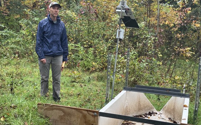
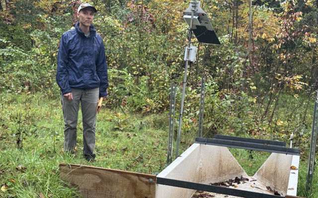
The group then took the short walk down the gently declining diversion terrace to the site where the upper flume is located, with its monitoring instruments, just above the first retention basin and berm.
“The idea of the flume is that as long as it's set dead level, you can monitor the water level flowing through it. I've got a sensor here that is sensing every five minutes the level of the water. Then you'll know how much flow is coming in,” Booth explained. “It’s really important to know how much runoff is flowing into this system, and then at the bottom, know how much is flowing out. During the 1960s, when they originally set this up, it's hard to know exactly how many big rainfall events they got. But they said in the report that they never got any flow coming out of these retention basins. So, that piqued my interest, and my research is focused on seeing how the same hill slope can handle our modern climate regime, with all of the heavy rainfall events.”
Booth said that in addition to the sensors located at the flumes, there is also a water level sensor in each of the three retention basins descending the forested hill slope.
“This is the first retention basin and berm, and if this fills up, it's going to spill over into the second one. The basins and berms were constructed to be perfectly level, to avoid having one spot where water concentrated and caused erosion, and possibly even failure of the structure,” Booth explained. “There's no way for water to get out of the basin without overtopping the berm, and this is a zone on the landscape that has potentially high infiltration capacity. Once we have a big event that fills this up, we'll know exactly how much that capacity really is.”
Booth said the new flume and sensing equipment had only been installed in June of 2026, and the largest rainfall event at that location this season had been about 2.5 inches. He said that to really get a sense of the effectiveness of the structure, the location would need to experience a high volume, high intensity rainfall event.
“Eventually, if these structures were to be located below croplands with the typical corn and bean rotations, the basins would fill in with sediment, and require maintenance,” Booth acknowledged. “So, that means that the upland land use would be a critical factor in the longevity of the effectiveness of these structures.”
Structure siting
Booth reported that the reason the hill slopes are so good for infiltration of runoff is their unique geology. He said that while the Driftless Region was never glaciated, it still experienced a very cold and harsh climate in that period. This resulted in a general reduction of vegetation, with living roots in the soil. The result was that precipitation caused erosion that created the ridge and valley system. In the course of that erosion, large rocks, gravel and sand were deposited on the slopes, creating a system that is hydrologically good for runoff infiltration.
“You've got the fractured dolomite at the top of the hill slope, and eventually we get into the sandstone, which we know is very permeable,” Booth observed. “I don't know if the researchers in the 60s had quite that idea in their mind, but they were basically using observations. They had a flume at the top of the hill slope, a flume at the bottom, and they just noticed a lot coming in and not a lot coming out, and thought it was really interesting.”
As far as siting the structures, Booth said there are clues such as gully development that can guide where the structures are placed. He said that the ridgetop clay functions as an infiltration barrier, so it’s good to locate the basins and berms lower where there is fractured dolomite or sandstone.
“That's part of what I'm hoping to get at with this research is better siting of where these are, and a little bit better guidelines,” Booth told the group. “Reading the old articles on this research reveals that they were trying to make it so that it was simple for somebody to do, cheap, and the only technical assistance needed was to lay them out, and then get a bulldozer.”
Booth said that really, this isn’t rocket science, and we know that the hill slopes have great infiltration capacity.
“I'm encouraging people, if they want to try it on their property, to go for it,” Booth said. “The only thing is, you would need a little bit of surveying, so you’d have to secure that kind of technical capacity.”
As far as securing modern NRCS support for installation of these kind of structures, Booth pointed out that NRCS’ predecessor, the Soil Erosion Service, wanted good technical standards so they could make sure that cost share dollars were effectively used. He pointed out that we're in a very different situation today with reductions in funding. He pointed out that there was a lot of money driving very large capital-intensive earth-moving projects starting in the 20s and 30s.
“We're in the opposite situation from then - we don't have money, and the dams don't work here - they fail,” Coon Creek Community Watershed Council board member Eric Weininger observed. “When our hillsides are working, we infiltrate water. There's a huge capacity to infiltrate water. Trimble’s research showed that before settlement we didn’t experience flooding in this area because the landscape held that much water. And so, without funding in an increasingly severe climate, we're trying to go back to low-cost solutions that infiltrate water that aren't capital intensive. It's flipped around.”