
DRIFTLESS - Most have heard about the drinking water problems in Kewaunee County, where residents have experienced brown water coming out of their taps. This problem with groundwater contamination resulted in the Wisconsin legislature enacting ‘sensitive area’ targeted performance standards for manure runoff in 15 counties on the east side of the state in 2018.
Out of those headlines, a water quality testing effort arose in Grant, Iowa and Lafayette counties – the Southwest Wisconsin Geology and Groundwater (SWIGG) study. Some had suggested that counties in the southern and western parts of the state also had an underlying fractured karst geology, similar to the eastern part of the state, that could make groundwater more vulnerable to contamination.
SWIGG round one results in November 2018 showed 42 percent of wells sampled were contaminated with either nitrate or coliform bacteria. This prompted Representative Robin Vos, Speaker of the Wisconsin State Assembly, to form a Speaker’s Task Force on water quality, which held hearings all over the state. The task force made recommendations to the legislature in 2019, and in 2020 those recommendations were considered and passed in the Assembly, but the Senate never took them up.
Also, in 2019, Governor Tony Evers declared the ‘Year of Clean Drinking Water.’ He directed DATCP, WDNR and the Department of Health Services to collaborate in addressing the widespread problem of nitrate contamination in the state’s drinking water. Chris Clayton from WDNR convened a technical advisory committee (TAC) to determine which areas of the state might require more targeted runoff management performance standards than the state’s one-size-fits-all rule. The state standards for safe drinking water for nitrate are 10 milligrams-per-liter or less.
Generally, the TAC’s work focused on areas with ‘P’ soils (porous, like sand); ‘R’ soils (rocky), and ‘W’ soils (wet soils). Water quality testing results in data bases maintained by WDNR, United States Geological Survey (USGS), and the Center for Watershed Science and Education in Stevens Point were reviewed.
The basic question were:
• Where in the state are more targeted standards needed?
• What would those standards be?
The TAC met all through 2020, with their work confined to virtual meetings due to the pandemic. Stakeholders from the three agencies and representatives of diverse agricultural sectors were invited to participate in the process. The result is proposed targeted runoff performance standards for certain areas of the state.
As part of this effort, the DNR is preparing an economic impact analysis (EIA) for proposed rule WT-19-19 relating to nitrate pollution in groundwater.
The DNR will accept written comments on the EIA from the public until April 10, 2021. A separate public comment period on the rule itself will be held after the EIA is finalized.
To see a copy of the economic impact statement, go to:
https://dnr.wisconsin.gov/sites/default/files/topic/Rules/WT1919FiscalEstimate.pdf
Please submit written comments by email to DNRNR151Revisions@wisconsin.gov or by mail:
Wisconsin Department of Natural Resources
C/O Mike Gilbertson – WT/3
P.O. Box 7921
Madison, WI 537
A separate public comment period on the rule itself will be held after the EIA is finalized. WDNR’s Chris Clayton estimates that the draft rule will be circulated for public comment in late spring or early summer. It is tentatively scheduled to go before the Natural Resources Board (NRB) in September or October of 2021. From there, it will be sent to the legislature if approved by the NRB. If passed by the legislature, it would be sent to the Governor to be signed into law.
To view a copy of the draft rule, go to:
https://dnr.wisconsin.gov/sites/default/files/topic/Rules/WT1919DraftRule.pdf
Lack of data?
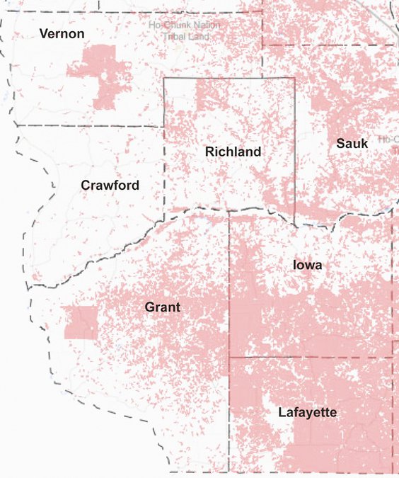
A quick look at the top level map generated for the targeted performance standards reveals that Crawford and Vernon counties stand out as having notably less area where the soils and geology are considered to make groundwater more vulnerable to nitrate contamination than other surrounding counties such as Richland and Grant. In Crawford County, according to Chris Clayton from WDNR, there are no areas included in the ‘sensitive areas’ that are not already covered under the NRCS 590 standard for nutrient management.
This, despite the fact that the hydrogeology of the counties is substantially similar:
• shallow depths of soil to bedrock
• widespread karstic features such as sinkholes which function as direct conduits to groundwater
• a fractured limestone layer of bedrock below the shallow soils which allows nutrients to percolate down into the groundwater system more rapidly
• aquifers located deep in the bedrock column in sandstone where water moves very slowly.
Some questions that might be posed regarding the areas included in the sensitive areas targeted performance standards for Crawford and Vernon counties pertain to the amount of relevant data available for the two counties, and how current that data is. Those questions include:
• Do Crawford and Vernon counties have as much water quality data as other counties under consideration for targeted performance standards? Since the data cutoff date was July/August 2020, this likely mean that none of the data from the Driftless Area Water Study (DAWS) in Crawford, Vernon and Richland counties is included in the map. DAWS was originally scheduled to take their first of two water samplings in April 2020, and the second in October. Instead, the first sampling was in October 2020, and the second is coming up in April 2021. These delays were due to the pandemic.
• Related to this, it may also be important to understand how recent the water quality data is for Crawford and Vernon counties, and at what depth in the bedrock profile the water samples are being drawn from. Water in shallower wells may be more likely to reveal any levels of contamination from modern land use, whereas water from deep wells located in the sandstone aquifers may be more likely to measure water from historic land use, where the ridge tops were covered in small dairy farms and disproportionately greater amounts of perennial grass cover.
• Are the soil maps for Crawford and Vernon counties as detailed and accurate as for those in some of the other counties being considered for targeted performance standards? Crawford and Vernon counties have historically been some of the poorer counties in the state. While other more populous and wealthy counties have had detailed soil mapping in place for decades, improved maps for the two counties are under development now. The new maps were scheduled to be released sometime in 2020 after peer review, but release was delayed due to the pandemic.
• Last, it has been alleged that the layer of clay found in the soil profile in counties like Crawford, Vernon, Richland and Grant counties, known as the Rountree Formation, is protective of groundwater. This clay layer is produced from the weathering of the bedrock below, and has been viewed as a largely impermeable layer. Researchers from the Wisconsin Geological and Natural History Survey (WGNHS) have been conducting research on the characteristics of this layer in Grant County in 2020. Results of this research have also been delayed by the pandemic.