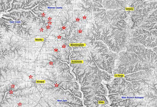
KICKAPOO VALLEY - Vernon County is home to nine dams in the West Fork Kickapoo Watershed, five in the Coon Creek Watershed, and eight dams in the Bad Axe River watershed. Monroe County has seven dams in the Coon Creek watershed, and Crawford County has only one PL-566 dam on Johnstown Road.
Vernon County
West Fork Watershed
The West Fork of the Kickapoo Valley has nine PL-566 flood control dams, and when full the impoundments behind them hold a total of 1,566,910,699 gallons of water.
Jersey Valley Dam (1)
The Jersey Valley Dam is located in the Town of Christiana with a hazard rating of high. It dams the Peaceful Valley Creek. The wet dam was completed in 1969, and when the impoundment behind it is full, holds 509,922,072 gallons of water. This was one of the dams that breached in the Labor Day 2018 floods.
Pilot Mlsna Dam (2)
The Pilot Mlsna Dam is located in the Town of Clinton, with a hazard rating of high. The dry dam was one of the two initial ‘pilot’ dam projects completed in the watershed in 1956. When full, the impoundment behind it holds 83,738,002 gallons of water. This was one of the dams that breached in the Labor Day 2018 floods.
Pilot Klinkner Dam (3)
The Pilot Klinkner Dam is located in the Town of Clinton, with a hazard rating of high. The dry dam was one of the two initial ‘pilot’ dam projects completed in the watershed in 1956. When full, the impoundment behind it holds 76,569,768 gallons of water. This dam overtopped, but did not breach in the Labor Day 2018 floods.
Ostrem Dam (4)
The Ostrem Dam is located in the Town of Clinton, with a hazard rating of high. It dams a tributary of the West Fork of the Kickapoo. The wet dam was completed in 1964, and when the impoundment behind it is full, it holds 67,772,390 gallons of water. This dam was damaged in the Labor Day 2018 floods.
Clockmaker Dam (5)
The Clockmaker Dam is located in the Town of Christiana, with a hazard rating of low. It dams a tributary of the West Fork of the Kickapoo. The dry dam was completed in 1971, and when the impoundment behind it is full, it holds 86,344,632 gallons of water.
Jacobsen Dam (6)
The Jacobsen Dam is located in the Town of Webster, with a hazard rating of low. It dams Halls Creek. The wet dam was completed in 1964, and when the impoundment behind it is full, it holds 30,302,078 gallons of water.
Hidden Valley Dam (7)
The Hidden Valley Dam is located in the Town of Viroqua, and has a hazard rating of high. It dams an unnamed tributary of the Seas Branch of the Kickapoo River. The wet dam was completed in 1966, and when the impoundment behind it is full, it holds 184,744,930 gallons of water. This dam was damaged in the Labor Day 2018 flood event.
Seas Branch Dam (8)
The Seas Branch Dam is located in the Town of Viroqua, and has a hazard rating of high. It dams the Seas Branch of the Kickapoo River. The wet dam was completed in 1966, and when the impoundment behind it is full, it holds 173,992,579 gallons of water.
Yttri/Primmer Dam (9)
The Yttri/Primmer Dam is located in the Town of Viroqua, with a hazard rating of significant. It dams Maple Dale Creek in the Bishops Branch of the Kickapoo River. The dry dam was completed in 1969, and when the impoundment behind it is full, it holds 353,524,248 gallons of water.
Coon Creek Watershed
The headwaters of Coon Creek lie in both Monroe and Vernon Counties. The five PL-566 dams in its headwaters in Vernon County, and the seven in Monroe County, together when their impoundments are full hold 361,572,219 gallons of water.
Vernon County
Swenson Dam (10)
The Swenson Dam is located in the Town of Christiana, with a hazard rating of low. It dams a tributary of Timber Coulee Creek. The dry dam was completed in 1962, and when the impoundment behind it is full, it contains 27,369,619 gallons of water.
Garlic Dam (11)
The Garlic Dam is located in the Town of Christiana, with a hazard rating of low. It dams a tributary of Timber Coulee Creek. The dry dam was completed in 1962, and when the impoundment behind it is full, holds 10,100,693 gallons of water.
Melby Dam (12)
The Melby Dam is located in the Town of Christiana, with a hazard rating of significant. It dams a tributary of Timber Coulee Creek. The dry dam was completed in 1962, and when the impoundment behind it is full, holds 23,785,502 gallons of water.
Dahlen Dam (13)
The Dahlen Dam is located in the Town of Christiana, with a hazard rating of high. It dams Coon Creek. The dry dam was completed in 1962, and when the impoundment behind it is full, it holds 24,437,160 gallons of water.
Struxness Dam (14)
The Struxness Dam is located in the Town of Christiana, and has a hazard rating of low. It dams a tributary of Timber Coulee Creek. The dry dam was completed in 1962, and when the impoundment behind it is full, it contains 11,404,008 gallons of water.
Monroe County
Tucker/Luckasson
The Tucker/Luckasson Dam is located in Monroe County, and according to the WDNR, has a hazard rating of low. It dams an unnamed tributary of Rulland Coulee Creek. The wet dam was completed in 1963, and when the impoundment behind it is full, it holds 88,299,605 gallons of water. This was one of the dams that breached in the Labor Day 2018 flood events.
Bilhovde Dam
The Bilhovde Dam is located in Monroe County, and according to the WDNR, has a hazard rating of low. It dams an unnamed tributary of Rulland Coulee Creek. The wet dam was completed in 1961, and when the impoundment behind it is full, it holds 31,116,650 gallons of water. This was one of the dams that breached in the Labor Day 2018 flood events.
Coon Creek 24
The Coon Creek 24 Dam is located in Monroe County, and according to the WDNR, has a hazard rating of low. It dams a tributary of Rulland Coulee Creek. The wet dam was completed in 1963, and when the impoundment behind it is full, it holds 22,156,358 gallons of water.
Coon Creek 25
The Coon Creek 25 Dam is located in Monroe County, and according to the WDNR, has a hazard rating of low. It dams a tributary of Rulland Coulee Creek. The wet dam was completed in 1961, and when the impoundment behind it is full, it holds 25,479,812 gallons of water.
Korn Dam
The Korn Dam is located in Monroe County, and according to the WDNR, has a hazard rating of low. It dams Coon Creek. The wet dam was completed in 1961, and when the impoundment behind it is full, it holds 67,446,562 gallons of water. This was one of the dams that breached in the Labor Day 2018 flood events.
Coon Creek 31
The Coon Creek 31 Dam is located in Monroe County, and according to the WDNR, has a hazard rating of low. It dams a tributary of Coon Creek. The wet dam was completed in 1961, and when the impoundment behind it is full, it holds 14,988,125 gallons of water.
Coon Creek 53
The Coon Creek 53 Dam is located in Monroe County, and according to the WDNR, has a hazard rating of low. It dams Berge Coulee Creek. The wet dam was completed in 1963, and when the impoundment behind it is full, it holds 14,988,125 gallons of water.
Vernon County
Bad Axe Watershed
The Bad Axe River is tributary to the Mississippi, feeding this great river directly on the western shores of Wisconsin. Portions of Crawford, LaCrosse, Monroe and Vernon counties lie within the Bad Axe-La Crosse River basin. The basin contains 400 miles of trout streams. When all eight of the dams in the Bad Axe Watershed are full, they hold a total of 5,473,598,011 gallons of water.
Raaum Dam (15)
The Raaum Dam is a dry dam located in the Town of Viroqua on Springville Road. It dams the Springville Branch of the Bad Axe. The hazard rating of the dam is low, and there is no public access. The dry dam was completed in 1963. When full the impoundment behind the dam holds 152,813,707 gallons of water.
Sidie Hollow Dam (16)
The Sidie Hollow Dam is located in the Town of Franklin, and has a hazard rating of low. It dams a tributary of the South Fork of the Bad Axe. The wet dam was completed in 1965, and when the impoundment behind it is full, holds a total of 280,212,768 gallons of water.
Tally Dam (17)
The Tally Dam is located in the Town of Franklin, with a hazard rating of low. It dams the South Fork of the Bad Axe. The dry dam was completed in 1965, and when the impoundment behind it is full, it holds 272,067,048 gallons of water.
Thompson Dam (18)
The Thompson Dam is located in the Town of Franklin with a hazard rating of high. It dams Hornby Hollow Creek. The dry dam was completed in 1963, and the impoundment behind it holds a total of 1,226,093,774 gallons of water.
Duck Egg Dam
The Duck Egg Dam is a dry dam located in the Town of Viroqua, with a hazard rating of significant. It dams the Springville Branch of the Bad Axe. The dam was completed in 1987. When the impoundment behind the dam is full, it holds 1,433,646,720 gallons of water.
Runge Hollow Dam
The Runge Hollow is located in the Town of Jefferson with a hazard rating of high. It dams the North Fork of the Bad Axe. The wet dam was completed in 1974, and the impoundment behind it when full holds 2,003,847,120 gallons of water.
Eagle's Park Dam
The Eagle's Park Dam is located in the Town of Sterling, with a hazard rating of high. It dams a tributary of Hornby Hollow Creek. The dry dam was completed in 1963, and when the impoundment behind it is full, it holds a total of 53,435,923 gallons of water.
Skildum Dam
The Skildum Dam is located in the Town of Sterling, with a hazard rating of low. It dams Bull Run. The dry dam was completed in 1963, and when the impoundment behind it is full, it holds a total of 51,480,950 gallons of water.
Crawford County
Crawford County is home to only one PL-566 Dam. The Johnstown Dam is located in the Town of Utica, with a hazard rating of low. It dams the Nederlo Creek tributary of Tainter Creek. The dry dam was completed in 1975, and when the impoundment behind it is full, it holds 58,975,013 gallons of water.
Note: the numbers correspond to the map published in this issue. If the dams don’t have a number, it just means that the area where they are located is not included in the map.