
PLATTEVILLE, April 22 — Spring in Wisconsin is known for mercurial weather, with anything from tornadoes to snow possible.
But nature may have outdone itself this past week.
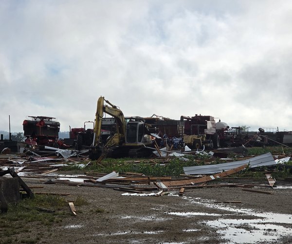
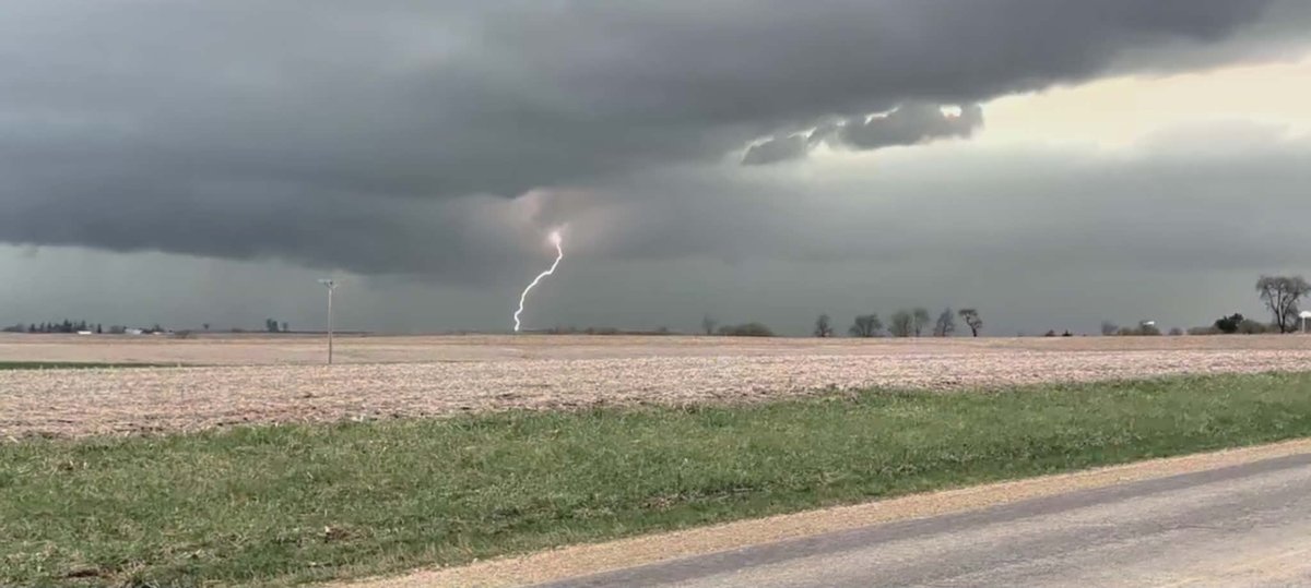
Storm warnings were issued for multiple waves of severe thunderstorms featuring five confirmed tornadoes April 14 and 13 confirmed tornadoes statewide Friday, plus high winds, large hail and heavy rain causing flooding. That forced cancellation of after-school activities and even resulted in schools ending classes early to get students home before forecasted severe weather.
The Wisconsin State Climatology Office reported Wednesday that based on issued National Weather Service warnings this has been Wisconsin’s most severe April in history.
The tornado outbreak Friday is in the top 10 for most tornadoes in one day in state history, according to the National Weather Service in Green Bay. This April has had more tornadoes than any April in state history, according to the NWS.
A flood warning is in effect for the Wisconsin River at Muscoda, with flooding above flood stage of 9 feet expected through early today.
A flood watch was in effect for the Mississippi River at McGregor, Iowa, but the Mississippi was expected to crest just below the 16-foot flood stage Tuesday morning. Crests were also expected below flood stage on the Mississippi at Guttenberg, Iowa, and Dubuque.
The first wave of severe weather took place April 14, with a tornado watch, two tornado warnings, seven severe thunderstorm warnings and a flash flood warning issued in Grant, Lafayette and Iowa counties.
The National Weather Service in La Crosse reported that a trained weather spotter sighted a tornado five miles east of Mount Hope at 5:25 p.m. Another tornado was sighted between Ridgeway and Barneveld, prompting the Iowa County Sheriff’s Office to tell Barneveld residents to take cover, though the tornado dissipated before getting to the site where nine people died in an overnight tornado June 9, 1984.
Wind gusts of 70 mph were reported west of Sinsinawa around 6:55 p.m.
Hail reports included 2¾ inches in Westby, 2 inches in Mount Hope, 1¾ inches west-northwest of Esofea in Vernon County and south-southeast of Hillsboro, 1¼ inches in Coon Valley, and 1 inch in Patch Grove, south of Gillingham in Richland County and east-northeast of Genoa.
Rainfall reports included 1.35 inches in Fennimore, 1.3 inches west of Platteville, 1.23 inches in Platteville, and 1.21 inches west-southwest of Muscoda.
The April 14 storms and late-week storm forecast were such that the NWS canceled the statewide tornado drill Thursday, although the tornado drill was carried out in Grant County. The City of Platteville delayed, then canceled its April 14 Common Council meeting because of the expectation that severe weather would be arriving just as people were coming to the Municipal Building for the meeting. The meeting was held Tuesday after the council’s annual organizational meeting.
One day later, severe thunderstorm warnings were issued for parts of Grant and Iowa counties and a flash flood warning was issued for central Lafayette County after another group of severe storms developed in the late afternoon.
Friday featured two waves of severe weather. The first, in the afternoon, included 1-inch hail southeast of Prairie du Chien and in west central Lafayette County, nickel-size hail at the Grant County Sheriff’s Office in Lancaster, 0.75 inches in central Iowa County, 0.7 inches in Boscobel, and five minutes of pea-size hail in Cassville.
A tornado watch, seven severe thunderstorm warnings, a tornado warning for Grant County, and flash flood warnings for Lafayette County were issued Friday.
The Iowa County Sheriff’s Office reported U.S. 18 in Cobb was closed due to water over the road.
Besides schools closing early and canceling after-school activities, the Wisconsin State Speech Festival in Madison Friday night was canceled. Students have been told to participate virtually by submitting videos.
To top off the fickle nature of Wisconsin springs, flurries were seen in parts of Southwest Wisconsin Sunday morning, though no snow accumulated. The low Sunday was 31, just below freezing.
Last week notwithstanding, April and sometimes March starts the state’s severe weather season. The month with the most tornadoes on average is June, and the month with the most severe weather — officially defined as tornadoes or thunderstorms with wind gusts more than 58 mph or hail of one-half inch or greater diameter — is July, according to the State Climatology Office.
Between 1950 and 2024, Grant County had the second most tornadoes in Wisconsin (71), behind only Dane County (93). Lafayette County (39) and Iowa County (33, with nine deaths from the 1984 Barneveld tornado) are in the top half in tornadoes since 1950.
The next wave of thunderstorms is forecast for Thursday, with a 90 percent chance of rain Thursday night. The NWS Storm Prediction Center Monday said severe weather was possible in Iowa Thursday. Other social media weather forecasters said another severe weather outbreak is possible Thursday.