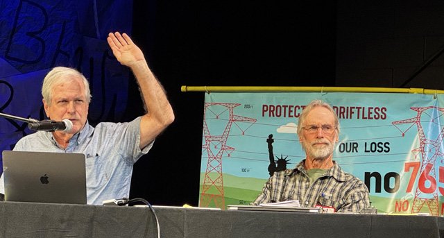
DRIFTLESS - On Sunday, October 25, hundreds of citizens took time out of a beautiful late-October day to hear about the potential environmental threats of the proposed MariBell and BECI electric transmission lines. The lines, if built, would run through the sensitive Driftless Region, home to globally rare, pre-glacial natural communities, underlain by a fragile karst geology.
The first of the three speakers assembled to help citizens understand these potential impacts was Curt Meine, co-editor of ‘The Driftless Reader.’ Meine’s talk aimed to enhance historical understanding of the unique wildlife ecology in the Driftless.
New developments
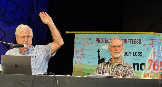
Prior to Meine’s talk, ardent No 765 Line volunteer Tennille Osthoff kicked off the event taking attendees through some new developments in the effort to oppose MariBell and BECI.
“I was in the army, so I’ve seen a lot of places, and this place is very special - there's not a lot of places like it. It might be a little bit like Missouri or West Virginia, but the Driftless region is extremely unique,” Osthoff told the crowd. “Our speakers will tell you more about that, but I just want to tell you a little bit more about the bigger picture of what has been going on.”
Osthoff said that as of August 23, 2026, 91 towns, villages, cities and counties have passed resolutions opposing construction of the proposed 765 kV lines. She said the number is growing weekly.
“On October 14, the Wisconsin Farm Bureau voiced concerns about the MariBell and BECI transmission lines, and stated that these projects are moving too fast and not working with landowners,” Osthoff shared. “This came just after 173 potentially impacted citizens packed the Wisconsin State Capitol for a ‘Day of Power’ on October 13, where citizens from the 10 potentially impacted counties brought their concerns to their elected representatives.”
Osthoff said that while citizens were at the Capitol, the Wisconsin Public Service Commission (PSC) announced that they would accede to one of the No 765 Line demands that a contested hearing be held to determine if Midcontinent Grid Solutions (MGS), the out-of-state BECI developer, could obtain status as a Wisconsin electrical utility. Without that status, they can’t apply to PSC for a permit to build the BECI line.
“So, that is very good news for us, as now a lot of the issues will be aired out in a public forum,” Osthoff said. “Also, on October 22, the Vernon County Board of Supervisors voted to call for a statewide moratorium on new transmission line construction.”
The board advanced a resolution demanding that Governor Tony Evers and the Wisconsin State Legislature immediately enact a moratorium on the construction of any proposed 765,000 kilovolt transmission lines in Wisconsin.
“It's really important if you're not from Vernon County, those resolutions are on the No 765 Line website - please download them and send them to your county. We want to set a chain of events, a reaction that every county across these impacted communities feels like they have something to pass, such as this call for a moratorium.”
Osthoff observed that so far, this issue had primarily been at the state level, but now a new threat had emerged at the federal level, with introduction to the U.S. Senate of the ‘Bipartisan American Affordability and Jobs Act.’ The bill’s authors claim it will reduce barriers to moving renewable energy to where it is needed. But it would also fast-track fossil fuel projects to support massive data centers by weakening or eliminating environmental review and restricting input from Tribes, communities, states, and the public.
“Now you wouldn't think that has to do with energy, but it does,” Osthoff explained. “What it would do if it was law right now, the transmission line developer wouldn't even file with the Wisconsin PSC - the developer would just file with the Federal Energy Regulatory Commission (FERC), and then there would be a 30-day input period, and you would have to travel. That would not only take it completely out of the landowner’s hands, but also out of the state’s hands.”
Curt Meine
‘Nature on the Line’ moderator Laurie Ellefson, introduced the event’s first panelist, Curt Meine.
“Curt is a conservation biologist, environmental historian, and writer. He serves as senior fellow with the Aldo Leopold Foundation in Baraboo, research associate with the International Crane Foundation, and is an associate adjunct professor in the UW-Madison Department of Forest and Wildlife Ecology,” Ellefson said. “He's also co-editor with Keefe Keeley of the ‘Driftless Reader,’ published in 2017.
“Thank you all for coming out on a beautiful afternoon. I'm amazed that you're here. I always say never organize an event involving conservation indoors on any weekend in October - nobody will show up, but that tells you how much we care about this issue and about this place,” Meine said in introduction. “And just a couple caveats before I begin - I'm affiliated with all those organizations, but I'm speaking for myself today.”
Meine said his talk would encompass discussion of the threats to the Driftless Region from the proposed lines, but would start with the area he knows best in Sauk County.
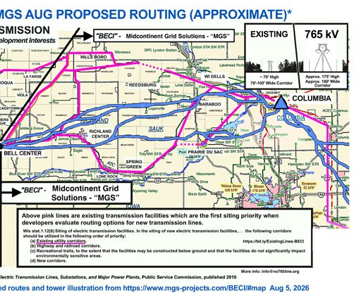
Meine referred to segment 13 and 14 of the map shared by BECI developers.
“This is just to the south of the Baraboo Hills, near the land that the Ho-Chunk Nation has named ‘Ma Wakacak’ or ‘Sacred Land,’ Meine said. “This is a portion of the former Badger Army Ammunition Plant, and I live just a few miles away. And yes, the line will go just to the south of one of the real iconic landscapes in southern Wisconsin.”
Meine said that the best map of the Driftless Region area, was created by Dr. Eric Carson of Wisconsin Geological and Natural History Survey, establishes that the Devil’s Lake area in Sauk County is the easternmost edge of the Driftless that was never glaciated.
“This area was completely surrounded by ice, but through the various stages of the same glaciations, the Driftless Region was never covered, and that has left us with this distinctive landscape,” Meine explained. “We’re sitting here in the very heart of the Driftless Region, but it includes some really important areas to the east. Even though we're focused on the Driftless, my brother lives literally underneath the substation at Sugar Creek in Walworth County, so I have friends and relatives all along the line.”
Meine shared another map made by a student at UW-Madison depicting the steep hills-and-valleys terrain of the Driftless. He superimposed the map of the proposed routes for the MariBell and BECI lines over the top of the map.
“This really brings out the amazing topography of this landscape, and also leads us into the discussion of why we have such a rich legacy of plants and animals and special natural features because of this varied, rugged topography of the Driftless, Meine said. “So if they were wanting to bisect the Driftless Region, they couldn't have done a better job.”
Meine then shifted into discussing the ecological features of the Driftless. As the best resource for information on this, he pointed people to a Wisconsin DNR report from 2015, ‘Western Coulees and Ridges Ecological Landscape.’
“The best biologists in the state got together to author this series of chapters on ecological landscapes, and this is the best succinct summary of the ecological features and values of this part of Wisconsin,” Meine said. “I was hoping Eric Epstein might show up today. Eric lives up the Kickapoo Valley and was absolutely key in writing this report.”
Meine said the report detailed some of the less common ecological communities in this region, which include:
- relict ‘northern’ conifer
forests
- dry, rocky bluffs includ-
ing bluff prairies and red
cedar and pine forests
- outwash terraces along
large rivers
- remnant tallgrass prairie
- cedar glades
- tamarack swamps
- cliffs, caves and talus
slopes
“This region is a complex mosaic of forests, agricultural lands, grasslands, wetlands, as well as these very special ecological communities that we have,” Meine stated. “And we're going to hear more about water, but we obviously are extra special, even globally, for the amount of spring-fed communities, springs, and cold water streams that many of us enjoy spending time on in the Driftless, as well as the larger rivers like the Wisconsin and Mississippi.”
Meine said that the DNR’s report shared the species of ‘greatest conservation need’ occurring in the Western Coulees and Ridged Ecological Landscape. These include:
- mammals: 1 significant
ly and 6 moderately as
sociated
- birds: 40 significantly
and 10 moderately asso-
ciated
- reptiles/amphibians: 17
significantly associated
- fish: 13 significantly
and one moderately as-
sociated
“Everybody's wondering what's that significant mammal, right? That's actually the long-eared bat,” Meine said. “For birds, of course, we have special species like cerulean warblers and peregrine falcons and loggerhead shrikes and barn owls, and all kinds of other species. These numbers signify our two rattlesnakes, our ornate box turtles, and I included invertebrates, even though DNR didn't go into great detail there.”
Meine explained the categories of threats and impacts (historic and current):
- conversion and frag
mentation of native eco
systems
- introduced species
- pollution
- overharvesting (wildlife
habitat)
- soil and water degrada-
tion due to unsustainable
agricultural practices
- mining
- afforestation
- fire suppression
- modified hydrological
cycles (drainage, dams..)
- development (urban,
residential…)
- commercial infrastruc-
ture
- climate disruption.
“I was asked to talk about threats, and we're going to talk about it generally at first. If you go back over 150 years of European settlement, you can see from this list how the landscape has been changed,” Meine said. “This combines what we might think of as historic, as well as current threats.”
Meine said that new threats have come along like data centers, and now mega-transmission lines like MariBell and BECI. Threats he listed included soil disturbance, compaction and etc.; impacts on rivers, streams, wetlands and groundwater; impacts on ecological communities like forests, woodlands, grasslands, etc.; impacts on species of special interest and concern; and landscape-scale impacts.
“The 175-foot height of the towers and lines could cause bird and bat collisions, and the 180-foot right-of-way could cause surface disturbance of soils, waterways and vegetation, and the tower footings into karst bedrock could impact groundwater,” Meine detailed. “Up to a distance of 540 feet, there could be an audible corona discharge; at 300-1,000 feet, there could be electromagnetic radiation; and for 1-5 miles there could be daytime visual impacts and nighttime aviation warning lights.”
Meine said that in the last week, he’d gotten curious about how the proposed lines might impact State Natural Areas, where the most rare and unique of Wisconsin’s rare habitats and species are preserved. He said that going to the DNR’s State Natural Area’s website is enlightening.
“I would say if you were planning to go by as many State Natural Areas as you could, you probably couldn't do much better than on the proposed transmission lines route,” Meine observed. “These areas are the highest value ecological gems of Wisconsin.”
Meine said that the line’s proposed route would affect Battle Bluff and Romance Prairie State Natural Areas in Vernon County; and Rush Creek State Natural Area, Lower Kickapoo Wildlife and Important Bird Area in Crawford County. He said that as you move east, there is an extensive list of areas that could be impacted, including Nature Conservancy properties or other private properties with conservation easements that are being restored, as well as farms where farmers are doing conservation work.
Meine said that a preliminary list of Wisconsin conservation properties and features to be directly impacted by MariBell and BECI includes a total of 108 sites, with 28 directly impacted. This includes the Ho-Chunk Nation, federal properties, state important bird areas, natural areas, and wild life areas; waterfowl production areas, fisher areas and recreation areas; U.S. and state trail systems; county properties; and private parks and conservation areas.
“Whenever I get to talking about the power line issues, I say that we need to not just be against the thing we don't want. We also need to be for something that's positive,” Meine stated. “So, even if we're in for a long fight, I hope we can devote time to talking and working together to care for our shared Driftless communities and landscapes, and as part of that, I hope out of this may come a more coherent vision for a sustainable energy future that doesn't have unnecessary costs associated with it. So, let's think together not only about how we get through this current bottleneck, but how we can use it as a springboard for talking about a truly sustainable energy future for Wisconsin, and policies to get us there.”