On Wednesday, June 17, an EF-2 tornado kicked up in Allamakee County, Iowa, near Harper’s Ferry. The tornado then jumped the Mississippi River into Crawford County about five miles north of Eastman. The 250-yard wide tornado, with max winds of 115 miles-per-hour was on the ground from approximately 5:10 p.m. to 5:25 p.m. in the county as it traveled southeast toward Steuben and Boscobel for a total of 32.8 miles.
The same tornado had been on the ground in Allamakee County, Iowa as an EF-2, starting just west of Waukon, Iowa. It travelled 11.6 miles before jumping the Mississippi River into Wisconsin.
The same system then jumped the Wisconsin River, and touched down again as an EF-1 tornado in Grant County. The 150-foot-wide tornado with max winds of 105 miles-per-hour was on the ground for 21.12 miles in Grant County, and then 6.63 miles in Iowa County east of Dodgeville.
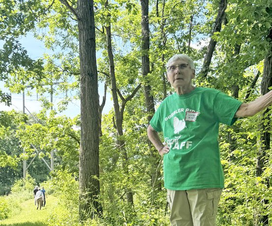
Marietta Township resident Kathleen Tigerman, who lives on Kickapoo Valley Road just to the west of Steuben, reported feeling terrified in her home.
“Was that ever a tornado,” Tigerman told the Independent-Scout. “We just had a big tree branch fall, but all the trees were bent over sideways, and the roar was scary. We don’t have a basement, and have big windows.”
According to National Weather Service-La Crosse, low pressure dropped through the Driftless Region during the afternoon hours of June 17. This system, combined with strong wind shear and a narrow axis of moisture and instability, and produced a cluster of thunderstorms over southeast Minnesota that then spread into northeast Iowa. One rotating storm quickly intensified as it moved through Allamakee County, Iowa with a radar confirmed tornado developing about five miles east of Waukon.
This tornado continued to the east-southeast, crossing the Mississippi River into Crawford County, and produced damage up to EF2 magnitude, as evidenced by twisted and snapped power poles along Highway 27.
The tornado lifted just before reaching Boscobel, but a new tornado touched down about four miles East-Southeast of Boscobel and continued east-southeast across northern Grant County into northwest Iowa County.
Fortunately there were no reported injuries with either tornado.
Due to storm damage, Highway 35 north and south at County N in Crawford County was blocked in both directions just north of Prairie du Chien. According to Scenic Rivers Energy Cooperative, there were over 4,000 rural people in Crawford County without power. Alliant Energy’s power outage map showed about 388 people without power in the same time frame.
Very dangerous
Crawford County Emergency Management Director Marc Mhyre, reached on Monday, confirmed that no resident of the county has stepped forward with a picture of the tornado. He said that there have been some reports of pictures from Allamakee County of the twister, but the Independent-Scout has yet to see one.
Mhyre conjectured that it was likely a ‘rain-wrapped’ tornado, meaning that it was almost impossible to see with the naked eye.
“This was a classic rain-wrapped tornado event, which makes them nearly impossible to see and absolutely increases the danger factor if people try to spot them before taking shelter,” Michael Kurz with NOAA federal said.
According to the ‘Cajun Navy’ website, rain-wrapped tornadoes are particularly dangerous:
“A rain-wrapped tornado is a tornado whose funnel is completely hidden by the heavy rain of its parent thunderstorm. In other words, the powerful vortex is there but you can’t see it – all you see is pouring rain. This happens in very moist, intense storms (often called high-precipitation supercells), when the storm’s rear-flank downdraft (RFD) pulls in rain and wraps it around the tornado. Because the rain acts like a curtain, a rain-wrapped tornado is virtually invisible to anyone on the ground. Meteorologists stress that these are especially dangerous – there may be no visual warning at all of the twister until it strikes.
“When this happens, observers see only rain and hear the roar of the storm – they might not notice anything strange until the tornado is upon them. In fact, forecasters say these tornadoes are ‘obscured by heavy rainfall’ and often go undetected without radar or other clues. Only specialized tools can reveal them – for example, Doppler radar may pick up strong rotation or even debris lofted by the wind, and spotters may notice the telltale power flashes from electrical lines arcing in the vortex.”
Storm damages
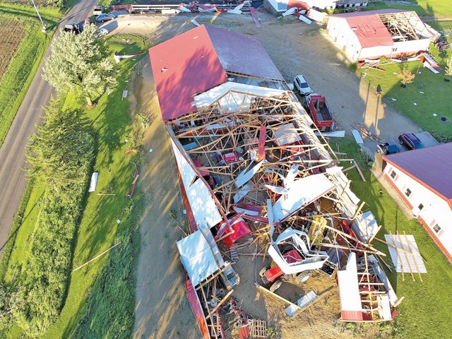
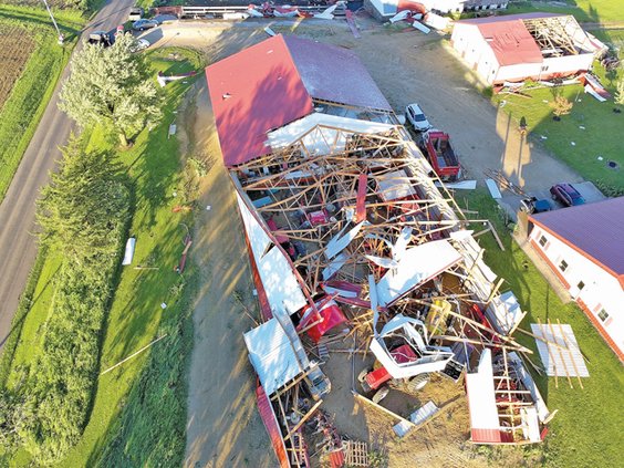
Myhre said that there had been approximately $80,000 in damages to public infrastructure in the county in the villages of Eastman and Steuben, and in Marietta Township. In addition, rural outbuildings on more than 20 properties in the tornado’s path suffered significant damage. The snapped power poles along Highway 27 north of Eastman were damage to private property owned by Alliant Energy, and were swiftly repaired.
“Clear Creek Road in Marietta Township will require a redoing of the seal coating, according to town chairman Teddy Beinborn,” Mhyre reported. “We will report damages to roads, bridges, and expenses related to debris removal.”
Myhre said that, combined for the storm in Allamakee, Crawford, Grant, and Iowa counties, federal recovery assistance may be available through FEMA’s Individual Assistance program. State funds for recovery will likely be available through the Wisconsin Disaster Fund, where Myhre hoped to recoup as much as $56,000 for the impacted villages and townships in the county. He said that residents with damage to their properties aren’t interested in making claims since damages are unlikely to meet the threshold for assistance.
Grant, Iowa counties
Two tornadoes were confirmed in the area last Wednesday late afternoon/early evening according National Weather Service survey crews.
The second, classified as an EF-1, developed just southeast of Boscobel and moved east-southeast across Grant County into northwest Iowa County.
The severe storms with heavy winds and rain made a brief, but significant appearance in Boscobel last Wednesday early evening. The storm came and went quickly in Boscobel, with strong winds and heavy rain and taking out heavy branches and trees.
Boscobel Director of Public Works Herschel Mark stated, “the City of Boscobel is in pretty good shape.” They had a few trees down, but not much reported for damage on structures. There were a few communication lines down, and one electric house service.”
Boscobel evening activities such Tom Innis’ ‘Music on Main’ performance still went on after the storm had passed. Last Wednesday’s performance was moved into the Hideaway Bar and Grill due to the weather.
There was a brief ‘intermission,’ when the tornado sirens went off and those in attendance took shelter in the basement, but Boscobel City Administrator Patricia Smith stated that “all was well after, and Tom Innis played his full set and people did come in after the storm had passed through.”
The most significant tornado damage of the storm extended southeast of Boscobel through Hickory Grove and Castle Rock, and exiting Grant County near Highland according to Steve Braun, Director of Emergency Management for Grant County.
Fennimore Fire Department Chief Todd Bresee reported that there was widespread damage in the Castle Rock area that included trees down, power poles down, and at least two buildings that were destroyed.
Impacted areas include the intersections of County S and Johnson Road, Witek Road and Neff Road, County G and Biba Road, and Shemak Road.
Breese stated that the Fennimore, Montfort, and Muscoda Fire Departments all worked with township and county personnel to clear roadways Wednesday evening.
Montfort Fire Department reported that a farm on Shemak Road had lost most or all of their buildings.
Iowa County Sheriff’s Office through a Facebook post stated the department responded to multiple reports of damage from Highland to south of Ridgeway and Barneveld.
The sheriff’s office reported seeing significant structural damage, wire damage and trees down. No injuries have been reported, and no major damage to residences have been identified.
Fennimore Times editor Jason Kreul contributed to this story.