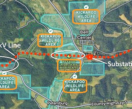

WEST FORK KICKAPOO/COON CREEK - A new study, commis-sioned by USDA-NRCS, and undertaken by research-ers from UW-Madison, documents that rainfall def-initions for storm events have been changing rapidly in recent years. The study was commissioned as part of the watershed study about dam failures in August of 2018. It shows that traditional rainfall defini-tions seem to be shifting down one level, so for in-stance the ‘100-year storm’ is becoming the ’50-year storm.’
Dr. Eric Booth, UW-Madison research scientist, presented the study results at the most recent meeting of the Monroe County Climate Change Task Force. About 20 people attended in-person including Democratic candidate for Wisconsin’s 96th Assembly District, Josefine Jaynes. Another dozen attended the meeting virtually.
The study is entitled ‘Stochastic Storm Transpo-sition (SST) to Update Rainfall Intensity-Duration-Frequency (IDF) Curves for the Coon Creek and West Fork Kickapoo Watersheds.’ The study’s authors are Daniel Wright, PhD; Zhe Li, PhD; and Eric Booth, PhD; all of UW-Madison.
The study can be downloaded at the West Fork Kickapoo and Coon Creek Watershed Study website at:
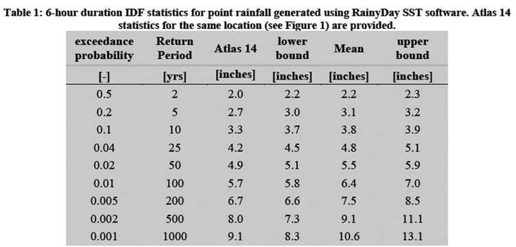
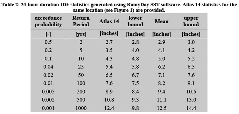
“Basically all the rainfall definitions (eg. 100-year-storm) used in engineering structures like flood control dams are based on the Na-tional Oceanic and Atmos-pheric Administration’s (NOAA) ‘Atlas 14 data,” Booth explained. “This data is accumulated by measur-ing rainfall amounts at a fixed location over a period of decades through radar verified with local rain gauges. The most recent data used is from 2012. In our analytic method, we substitute ‘space’ for ‘time,’ which allows for more rapid assessment of changing rainfall trends.”
As it says in the ‘Back-ground and Introduction’ section of the study results report, “While Atlas 14 is currently the most reliable and widely used source of IDF estimates in the U.S., there are growing concerns about the method’s ability to 1) incorporate the most recent heavy rainfall events in a given region and 2) account for a non-stationary, warming climate that is resulting in a higher frequency of heavy rainfall events. This inability to account for a widely-recognized phenomenon has the potential to alienate and frustrate regional stakehold-ers who are participating in a watershed planning pro-cess that will lead to long-term positive economic outcomes in the region.”
Further in the ‘Findings’ section of the study results report, it reads “By consid-ering observed storms from a surrounding area that did not strike the location of interest but could have done so, it is possible to use SST to derive such rare events [100-, 200-, 500- or 1,000-year rain events] from relatively short radar rainfall records.”
When queried about whether the data showed that rainfall definitions appeared to be trending one level downwards (eg. 200-storm becoming the 100-year storm; 100-year storm becoming the 50-year storm), Booth had this to say:
“Yes, I would agree with that interpretation. It does depend on the return period and storm duration, but generally the updated statis-tics are showing a shift from one return period category to the next one down for a given rainfall amount. Alternatively, you could say something like "the 100-year and 200-year events are increasing by about two-thirds-of-an-inch for the 6-hour and 24-hour durations,” Booth explained. “These statistics are how we will be incorporating a changing climate into engi-neering designs, and this is how climate change adapta-tion connects with projects on-the-ground.”
Booth went on to say, “the other point to make here is that these revised estimates are just a snapshot in time and with a climate that continues to warm, these revisions are very likely to increase further over the next several dec-ades.”
Booth explained that his colleague, Dr. Dan Wright, has just received some new funding to incorporate cli-mate change projections into his methodology so that researchers can make similar estimates (tables and figures) for 20 and 50 years into the future.
His website, where his new research grant is described is:
Many uses of Atlas 14
In addition to the engi-neering designs for flood control dams, Atlas 14 data is also used by other state and federal agencies in a variety of ways.
According to Eric Struck of the Wisconsin DNR, engineering staff from his department say that USDA-NRCS, DATCP, and the DNR CAFO program all use Atlas 14 rainfall depths in calculating rainfall vol-umes for all of their review-able facilities - manure stor-age structures, pipe capaci-ty, etc. He said that the state NR 243, which regulates ‘Animal Feeding Opera-tions,’ has the old Technical Paper 40 rainfall depths, but says that the wording is such that they use newer, approved data. Struck said that “agen-cies switched around 2015, and updated rainfall depths are currently being worked on.”
Mike Dreschmeier, USDA-NRCS Richland Center, reports that his agency uses the NOAA Atlas 14 data when determining runoff from small watersheds for the designs of many conservation practices including grassed waterways, diversions, dams and other grade stabilization structures.
Jennifer Heaton-Amhrein, DATCP Land Resources Section Chief, reports that, according to a DATCP engineer, DATCP uses Atlas 14 data for the DNR CAFO Program, the DATCP Conservation Engineering Section, and the conservation partners we service and work with such as NRCS and County Land Conservation Departments have been using this revised rainfall data for projects since 2015 for the following types of practices:
• Animal waste storage facilities (manure, barnyard runoff, milk house waste)
• Feed storage area runoff collection and treatment
• Grassed and lined waterways
• Roof gutter and clean water diversion
• Vegetated Treatment Areas (VTA)
• Ponds
• Other erosion and sediment control practices (grade stabilization, Water & Sediment Control Basins, etc.)
The Atlas 14 rainfall data has been incorporated into the majority of hydrology programs and analysis tools that we use in designing conservation practices that use peak runoff and runoff volume calculations.
To learn more
For those interested in learning more about Booth’s work, there are several options available.
First, the Watershed Study will be offering public scoping meetings for the Watershed Planning process for the West Fork Kickapoo and Coon Creek watersheds on Wednesday and Thursday, September 16 and 17.
The meetings are first-come-first-serve for the in-person meetings, with attendance limited due to COVID-19. But there is also an option to participate virtually, available at the Watershed Study website. The meetings will take place as follows:
• The West Fork Kickapoo Watershed meetings will be held on September 16th at the Cashton Community Hall, 812 Main Street, Cashton, WI at 1 p.m. and 6:30 p.m.
• The Coon Creek Watershed meetings will be held on September 17th at the Coon Valley Legion Hall, 105 Park St, Coon Valley, WI, at 10 a.m. and 6:30 p.m.
In addition, Dr. Booth will make a presentation that is part of the Kickapoo Valley Reserve’s ‘Driftless Dialogues,’ as follows:
• Saturday, Oct. 3: ‘Riparian Forests, Stream Restoration and Persistent Flooding in the Kickapoo Valley.’ Eric Booth, Department of Agronomy at UW-Madison, and Caroline Gottschalk Druschke, Department of English, will utilize the Wolf Valley section of Weister Creek restoration to see some lingering symbols of flooding and changes to the valley. This talk will meet at the intersection of Vernon County P-West and Wolf Valley Road.
Other contributions
In addition to being on the team to analyze new rainfall trends, Booth is also leading a team that is performing other activities that relate to the Watershed Study. Booth is leading a team of six UW-Madison students who are pursuing masters degrees in ‘Water Resource Management.’ Their activities include:
• looking at flood resilience, and analyzing the flooding trends in recent years. Their research shows that from the time of European settlement to the 1930s, there was a pattern of increasingly severe floods. After the activities, which were kicked off by the iconic ‘Coon Creek Watershed Improvement Project,’ undertaken by the CCC and the Soil Conservation Service, there was a decreasing trend of severe flooding events through 2000. Then, in the years 2007-2019, the trend reversed, with severe flooding events increasing again.
• looking at different ways to enhance the water inflitration capacity of soils in the watersheds. Analysis of USDA Ag Census data showed a precipitous loss of contour strips between 2004-2018, which seems to correspond to the loss of dairy farms. Their research shows that grassed waterways and prairie strips have high water infiltration. Well-managed pasture has slightly higher infiltration than no-till corn and bean fields. Booth acknowledged that no-till systems, without living roots in the soil year round show lower rates of water infiltration.
• gauging different community perspectives about flooding through interviews with landowners.
• investigating how to improve flood management institutions at the local, county, state and federal levels.
• investigating different flood mitigation strategies.
In addition, Booth’s team has recently been funded for two additional studies:
• Interactive dynamics of stream restoration and flood resilience in a changing climate – National Science Foundation funding
• Grassland 2.0 - agroecological transformation to perennial grassland agriculture – USDA-NIFA funding.

Flood monitoring
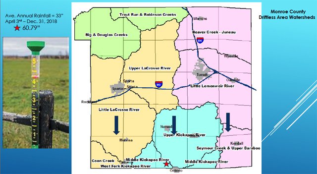
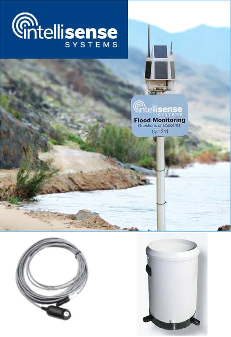
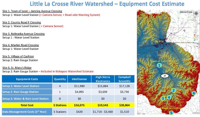
Members of the Monroe County Climate Change Task Force moved forward at their recent meeting with the purchase of the first two of five planned flood monitoring stations in each of the two priority watersheds they are focusing on – the Kickapoo River, and the Little LaCrosse River.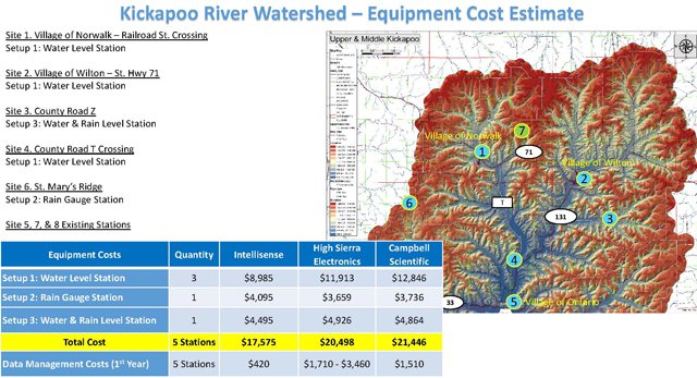


The funding for the purchase of the first four of the planned ten stations has come from the following sources to date:
• U.S. Fish & Wildlife Service (for the Little LaCrosse watershed) - $9,000
• American Family Insurance - $2,500
• Village of Wilton - $4,000
• Kickapoo Valley Reserve - $1,000
• Three to five individual donations - $500 each
The Kickapoo Valley Association has been actively fundraising for the project. Many potential funders have an annual funding cycle, so there may not always be as quick a response as might be hoped.
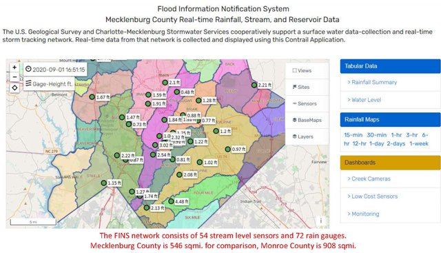

The board voted to select the Intellisense monitoring stations as the most cost effective of the three systems the task force had identified would meet their needs and fit their budget. This device, as Anderson explained, was developed through grant funding from the Department of Homeland Security in partnership with Mecklenberg County and the City of Charlotte in North Carolina.
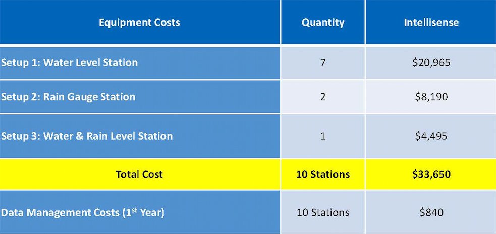

Ultimately, purchase of all ten of the planned flood monitoring stations will cost $33,650. Funding raised to date is somewhere between $15-18,000.
One meeting participant questioned if it made sense to buy and install the stations one or two at a time, versus putting all five in place in each watershed.
“If you ask Marcy West down at the Kickapoo Valley Reserve if she’d rather have two stations upriver from her or none, she’s going to tell you she wants the two,” Monroe County Conservationist Bob Micheel said.
Monroe County Emergency Management Coordinator, Jared Tessman had this to say:
“Last Thursday, August 27, was two years to the day of the rain event that caused the 2018 floods,” Tessman said. “On August 27, 2020, we received eight inches of rain in a very short period of time near Tomah, and if that rain had fallen just 30 miles to the west into the Kickapoo River watershed, we could have had a repeat of 2018.”

Next meeting
The next meeting of the Monroe County Climate Change Task Force will take place at the County Courthouse in Sparta on Wednesday, Oct. 7, from 2:30-4:30 p.m. Interested citizens can attend in-person, wearing masks and social distancing. A virtual option to participate is also available through a link on the Monroe County Land Conservation Department website:
http://www.co.monroe.wi.us/departments/land-conservation/
The featured guest speaker at that meeting will be Fred Clark, Executive Director of Wisconsin Green Fire.
Wisconsin’s Green Fire supports the conservation legacy of Wisconsin by promoting science-based management of Wisconsin's natural resources. Their vision is that Wisconsin’s citizens understand and support scientific and thoughtful long-term management of natural resources, and value the many benefits of clean water, clean air, and healthy ecosystems.
Fred Clark joined Green Fire as their first Executive Director from a 30-year career in Wisconsin conservation. Fred was previously the director of The Forest Stewards Guild – a national organization dedicated to sustainable forestry and forest science. He has worked as a forest ecologist for Wisconsin Chapter of The Nature Conservancy, as a forester for the Wisconsin Department of Natural Resources, and as a consulting forester and owner of a forestry contracting business.
He was appointed by both Governors Doyle and Walker to the Wisconsin Council on Forestry, where he served from 2004-2014. He also served three terms as a Representative to the Wisconsin State Assembly between 2009-2014, representing Sauk and Columbia counties, and he has served on the Assembly Committees on Forestry and the Environment, and the Committee on Natural Resources.