DRIFTLESS - The first two of four planned community education/discussion meeting about learning to live without the flood control dams in the Coon Creek and West Fork Kickapoo watersheds were held in rural Coon Valley on May 25. The two meetings drew a total of almost 50 participants, and were sponsored by the Coon Creek Community Watershed Council (CCCWC).
The last two in this series of meetings are planned for Thursday, June 1, at 4:30 and 6:30 p.m. at the Norskedalen Nature & Heritage Center in rural Coon Valley.

“These meetings are not about the decision of whether or not to decommission the dams, but rather about our communities learning to live without them in place,” CCCWC president Nancy Wedwick explained. “Watersheds connect us all, and don’t care about political boundaries – we need to start to think about things differently now that the Natural Resources Conservation Service (NRCS) has put forth the decommissioning proposal.”
The proposal calls for a 45-day online public comment period in July and August, and then decommissioning 23 PL-566 flood control dams in the two watersheds in the summer and fall of 2024. LaCrosse, Monroe and Vernon counties would have to approve the proposal for the Coon Creek dams, and Vernon County would approve the proposal for the West Fork Kickapoo dams.
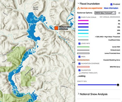
Information about NRCS’ planning process can be found online at www.wfkandccwatersheds.com.
“After the rain event that led to historic flooding in August of 2018, when five flood control dams failed in one night, we’ve had to learn to think about water differently,” Wedwick said. “Our ancestors here in this landscape were very brave in facing their problems with soil erosion and water runoff, and they figured it out – now it is our generation’s turn to face our problems and make the changes needed for ourselves and future generations.”
Wedwick, whose ancestor was active in the Coon Creek Watershed Council in the 1950s and 1960s, told the story of her own learning journey about land use, soil erosion and flooding.
“My training is as an attorney, and I didn’t start out knowing very much about conservation,” Wedwick said. “My husband and I own property both on the ridge and in the Village of Coon Valley, and in 2018, the first I knew about the valley flooding was when my brother-in-law arrived at my house in the middle of the night asking to stay with us because the house in the village was flooded.”
Wedwick said that the next day she had gone down to Coon Valley to see what had happened and what needed to be done, and was overwhelmed with the level of community engagement and support that she encountered.
“I realized that the land use choices that we make on the top impact what happens to people in the valley,” Wedwick said. “Right then and there, my husband and I decided to re-install the contour strips on the land, implement crop rotations and plant shrubs and trees – we had learned that having living roots in the soil year round is what will make running water walk.”


Everyday solutions
Vernon County Zoning and Sanitation Director Matt Albright, who previously served the county as a conservation technician, discussed the steps that homeowners, landowners and farmers can take to reduce soil erosion and stormwater runoff.
“We have to remember that the dams in the Coon Creek Watershed only controlled 17 percent of storm water runoff, and that the rest was up to land use decisions,” Allbright emphasized. “With the increasingly intense rainstorms we’re seeing, and the high gradients of our hills and valleys terrain, we’re always going to see storm water runoff – the questions are how much and how quickly.”
Albright reminded the groups of the sheer volume of rain that had impacted local watersheds in August of 2018, from August 26 through September 5. Amounts ranged from 23.42 inches in Elroy, 19.06 inches in Hillsboro, 18.06 inches in Westby, 15.57 inches in Ontario, 14.40 inches in LaFarge, 11.56 inches in Readstown and 9.62 inches in Viroqua.
In his presentation, ‘Our Watershed,’ Albright said that all properties – large or small – in a watershed can be part of the solution or part of the problem.
“Everyone’s choices matter, and everyone can be a part of the solution,” Albright stated.
Albright listed simple practices homeowners can use to infiltrate, retain and slow runoff from their properties. Those practices include use of rain barrels or installing rain gardens, aerating lawns and planting more diverse and deep rooted plant species in the lawn, and mowing the lawn to only a three-to-four inch height. Green infrastructure options include permeable patio pavers, sidewalks and driveways, and adoption of more clean energy options.
Landowners, according to Albright, have two major options that have potential to make a big difference. The first is woodlot maintenance, especially controlling invasive species to increase the diversity of species in the understory to soak up more rain. The other is maintenance of stream buffers along with planting deep rooted native species.
For agriculture, Albright emphasized use of true no-till, planting cover crops, adoption of managed rotational grazing, and the planting of native buffer strips on less productive acres. Infrastructural solutions include small dams and farm pond water retention structures and terraces and diversions.

Since that storm event in 2018, interest in solutions to erosion and flooding in the Coon Creek and West Fork Kickapoo watersheds has been increasing. Both watersheds were the location of early work by the Soil Conservation Service and the Civilian Conservation Corps in the 1930s and 40s, where the success of the work done there inspired the nation and the world.
With climate change fueled problems impacting communities across the nation and the globe, the hope is that the region will once again be a laboratory of solutions and an inspiration.
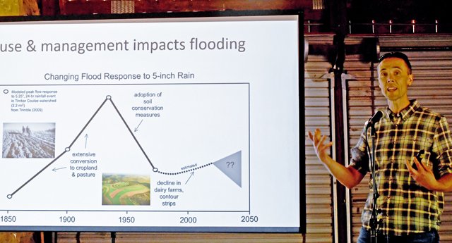
“The university community recognizes the rich history in the Coon Creek and West Fork Kickapoo watersheds and the spirit of collaboration and experimentation that helped turn things around in the period from the 1930s to the 1970s,” UW-Madison research hydrologist Eric Booth told the group.
Since 2018, this has meant that the university community in particular kicked into high gear on research about the changing definition of rainfall events, land use changes and their implications for water infiltration and erosion and runoff prevention, and how the culture and economics of farming can best be supported while also providing multiple co-benefits for the environment and surrounding communities.
Eric Booth, research hydrologist from UW-Madison, and Randy Jackson and Claudio Gratton from Collaborative Landscape Design in Grassland 2.0’s Ridge & Valley Learning Hub addressed the group at the two meetings on May 25.
In their talks, the scientists talked about the new tools their teams have developed to help farmers and landowners make decisions about their operations designed to increase profitability, and provide co-benefits such as storm water runoff and soil erosion control, carbon sequestration, pollinator habitat, and more.
Those tools are the Grazescape, Smartscape and Heifer Compass tools, and the Floodscape tool. The first three are designed for farmers to make the best decisions for profitability in their operations, and Floodscape helps farmers and landowner see how their land use decisions can best support reduction in flooding in their communities.


“Land use changes alone can’t prevent flooding, and I’d argue that historic replanting of steep hillsides in trees did as much or more than changes on agricultural lands,” Booth said. “And the predominant land use in all the watersheds is in forest, with 48 percent of lands in the Coon Creek watershed in deciduous broad-leaf forest, and only 19 percent in crop production and 25 percent in pasture.”
Booth explained that the major benefit of the flood control dams in the Coon Creek and West Fork Kickapoo watersheds was twofold:
• reducing the threat of flash flooding in an area of about two-to-three miles downstream, and
• retaining and slowly releasing about 17 percent (25 percent in WFK) of total storm water runoff, giving communities downstream more time to prepare.
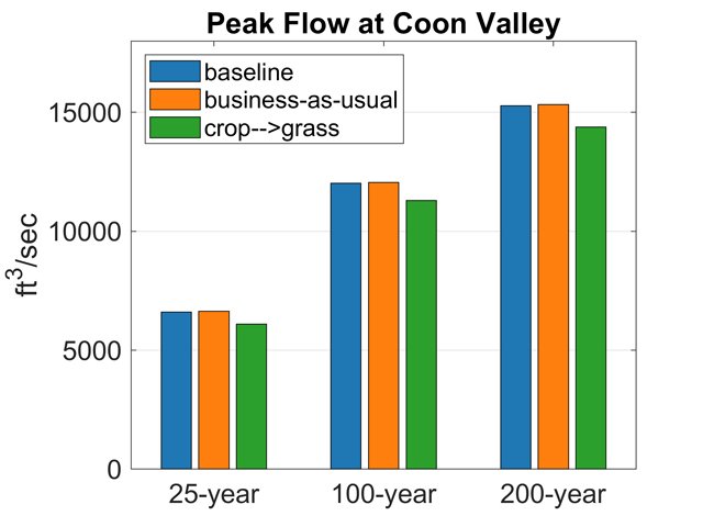
“We believe that about a 10 percent increase in acres in grass in the Coon Creek Watershed could reduce flooding levels in communities downstream by about half a foot,” Booth said. “This impact would be similar to having the dams in place.”
In the end, Booth’s Floodscape modeling suggests that even with adoption of more conservation practices on cropland such as the planting of cover crops, the change in runoff will be relatively small. He said that the modeling results indicate that it is more acres in grass and better woodlot management that will move the dial on storm water runoff.

Grassland 2.0’s Randy Jackson pointed out that from a profitability standpoint, corn and bean rotations are only really profitable with government subsidies added in. He said that the average net return from a corn and beans operation per acre is $204. He contrasted this with net return per acre from contract heifer grazing of $247 per acre, and net return per acre from owned land and cattle heifer grazing of $264 per acre. He said the net return per acre from beef stockers during the grazing season was $169.
In addition, Jackson emphasized the many co-benefits realized from a managed rotational grazing system for the landowner, the community and the enviroment.
Those co-benefits include potential soil carbon gains (rather than losses), biodiversity and habitat for birds, pollinators and game, little use of inputs and antibiotics, increased animal welfare and well-being, more opportunities for new generations of rarmers, diversified rural landscapes and communities, and increased marketing opportunties for high-value, healthy and nutritious products.
“If managed rotational grazing is more profitable, and you can also realized all of the co-benefits, why wouldn’t you do it?” Jackson asked.